This website shares information about the riverside path at Dinton Pastures along the River Loddon, including photographs showing accessibility during flood conditions. The images are informal and intended as a helpful guide. We walk this area daily and created this resource to help ourselves—and others—understand what to expect as river levels rise.
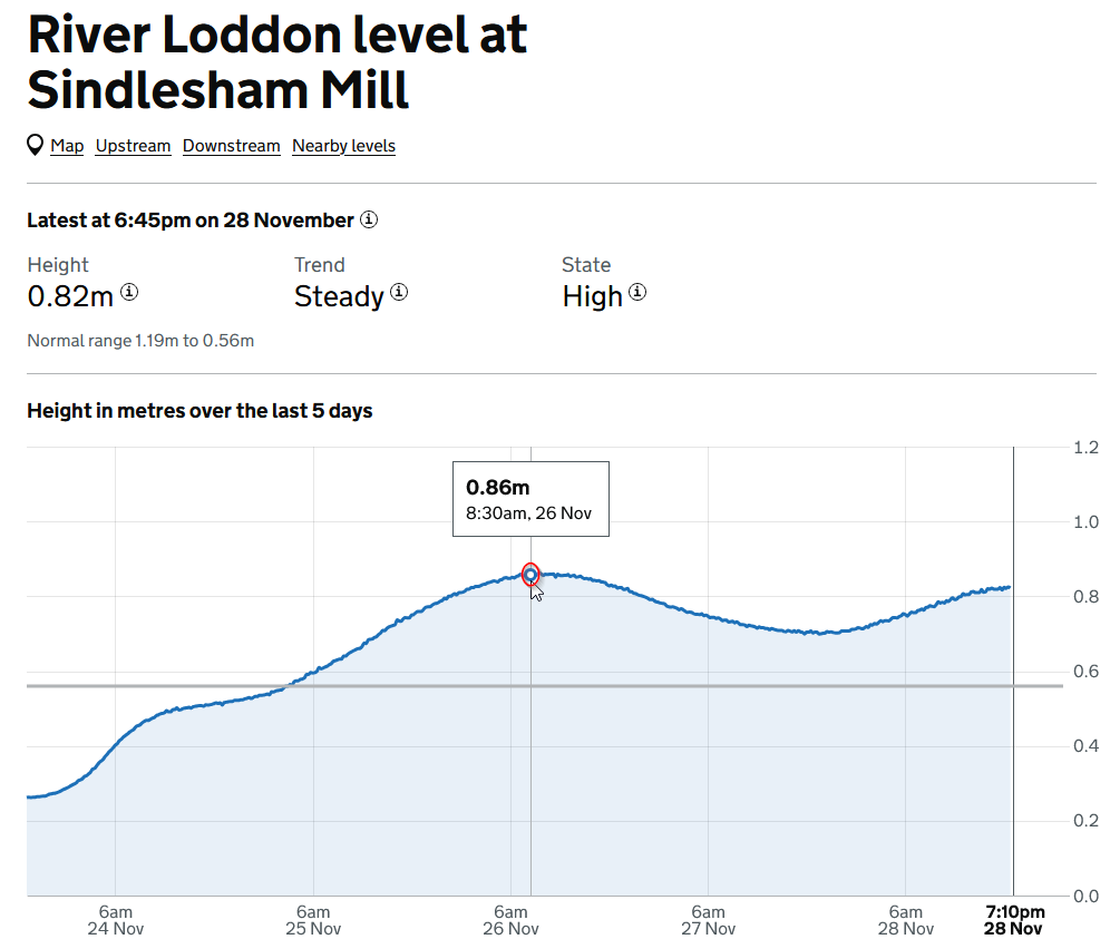
The Depth of the River Loddon at Dinton Pastures.
Quick Menus
Jump to observations at different height readings (river height readings taken at the upstream station of from
Sindlesham Mill)
Jump to observations at different dates
Summary and learnings so far
I don’t yet have enough data to predict how the river levels at Dinton Pastures correspond to the measurements taken at Sindlesham Mill. I also can’t say with confidence how rising versus falling water levels affect what you actually see on the ground.
Based on what I’ve observed so far, my rough guide would be
Less than 0.56 - Walking is generally fine
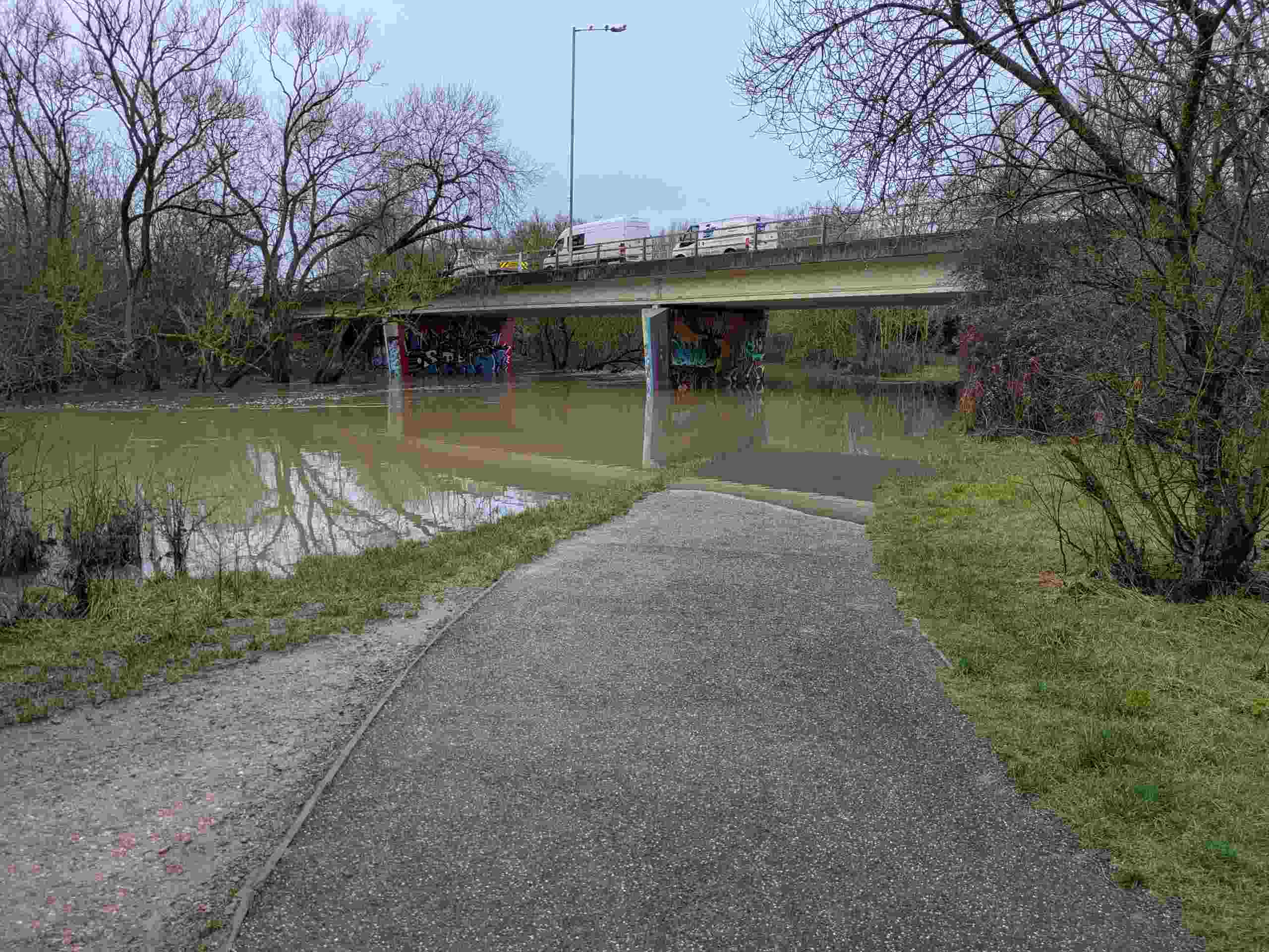
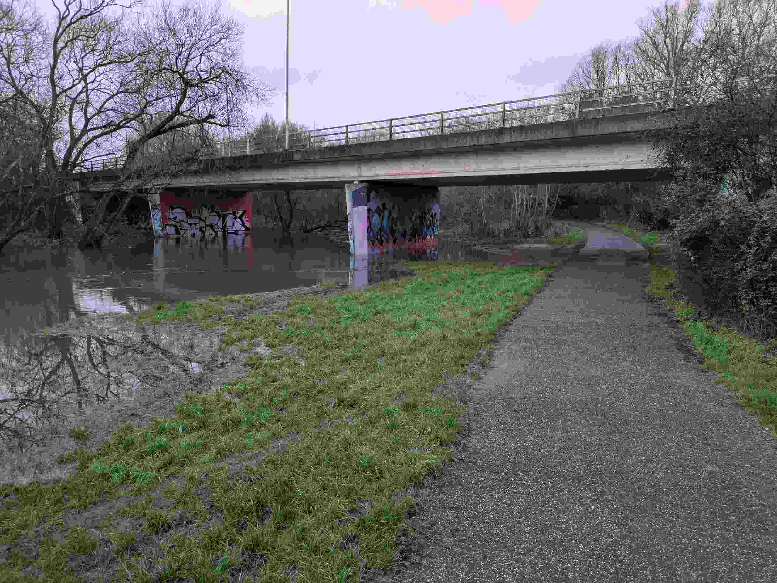
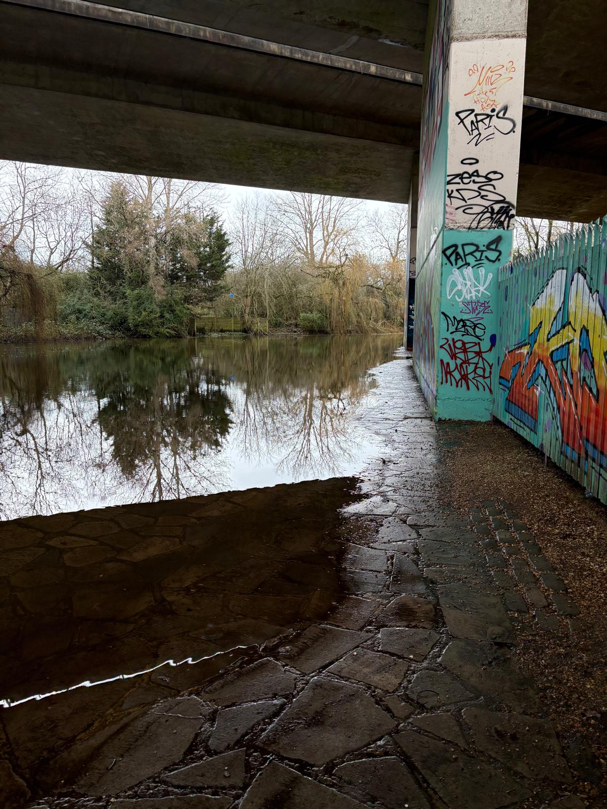
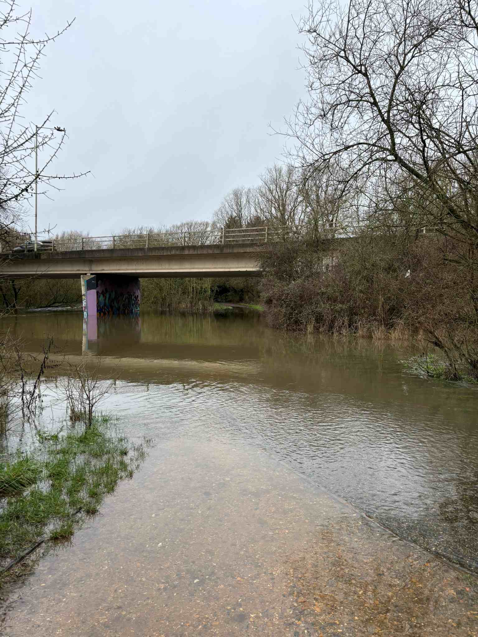
Around 0.65 - The path under the A329M begins to narrow. The river spills out of its banks in several places, but none of these usually block my regular walking route.
Slightly above 0.65 m – The point at which the river first reaches the path is still uncertain, but it seems not to be far above this level.
Around 0.78 Full height wellies are just about enough under Bader Way. It’s only passable if you move very slowly, get lucky with footing, and your wellies are at least as tall as mine. I recommend that if you decide to walk, take a walking stick with you to check the water depth .
Over about 0.78. Be prepared to walk through deep water. The currents can be strong where the river flows out of its banks and back across the meadow, which makes this section somewhat risky. If you choose to proceed, I recommend taking a walking stick to help you check the water depth as you go.
Flood Observations
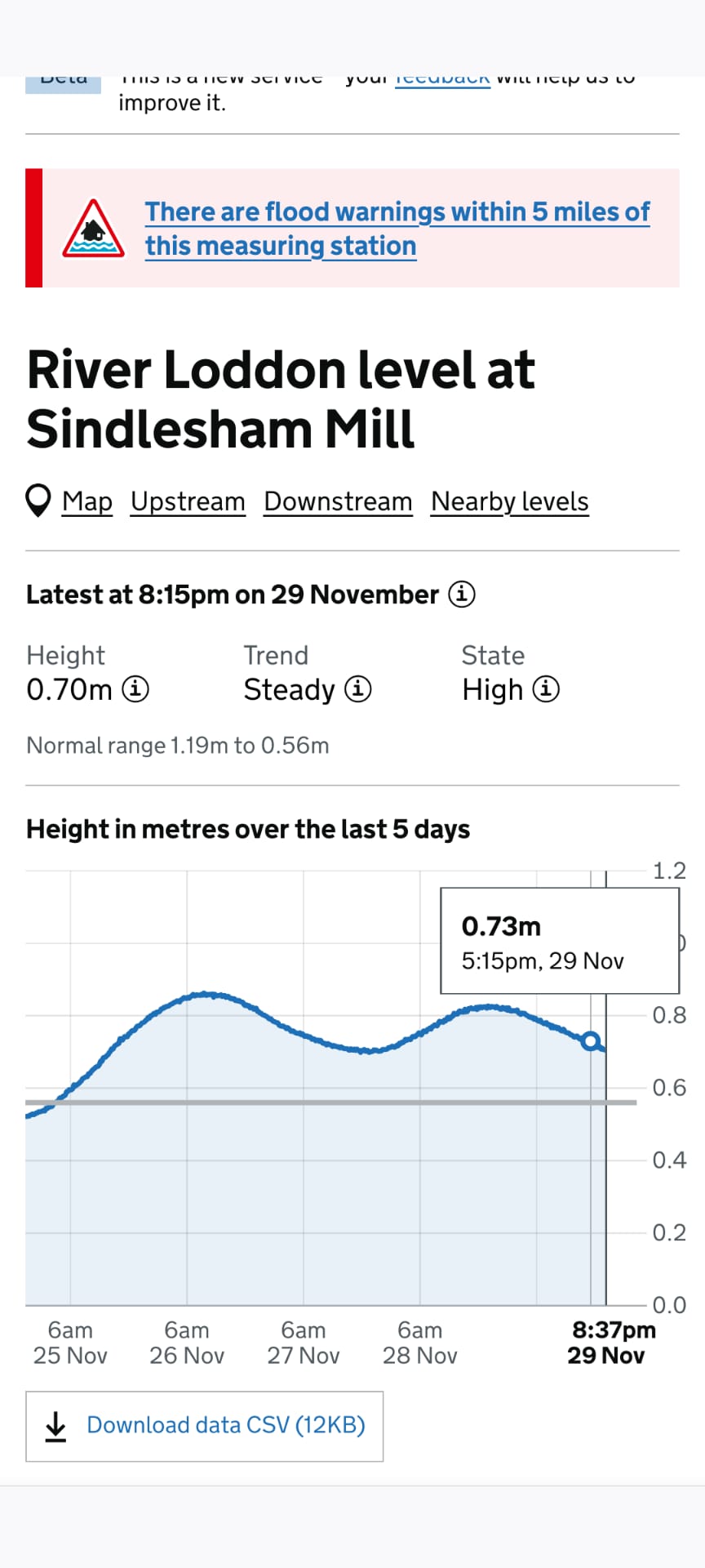
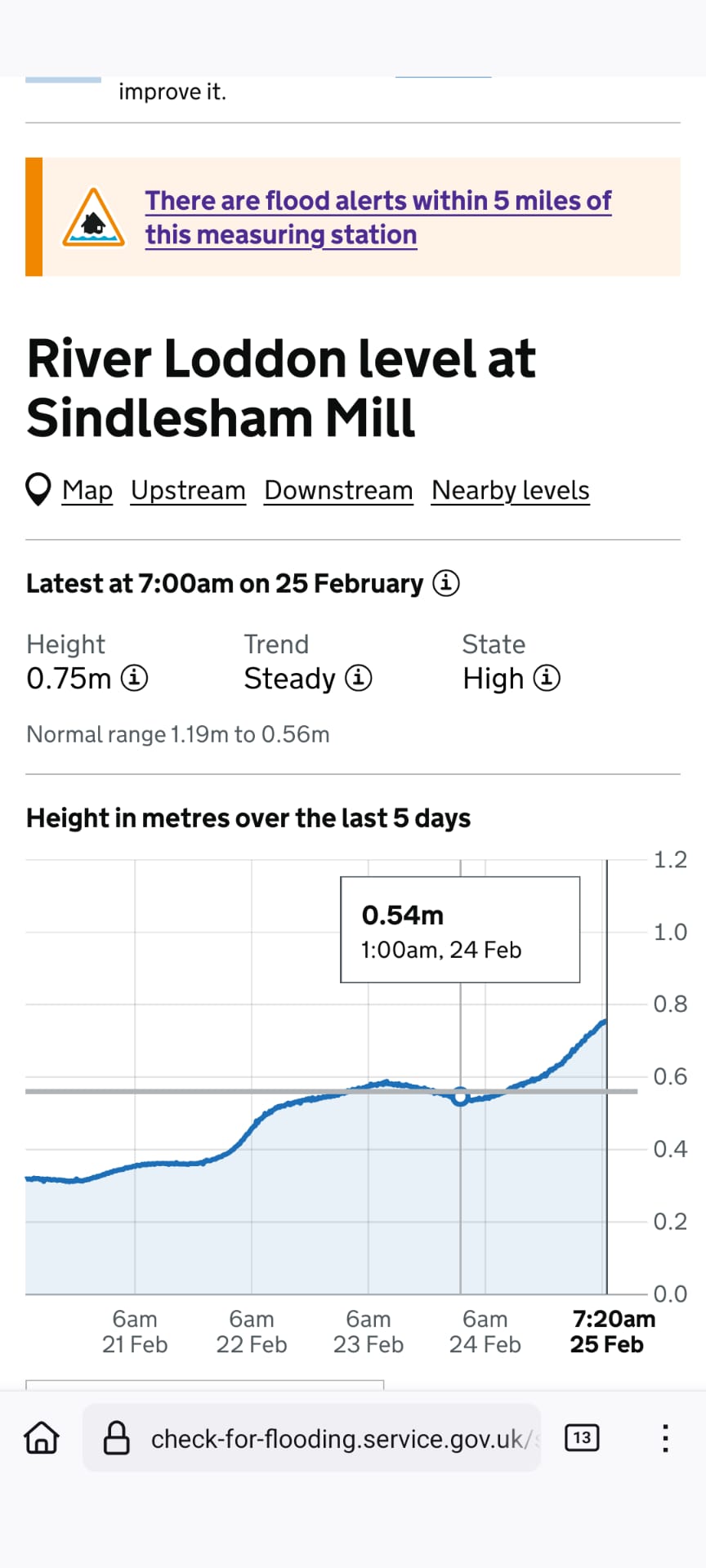
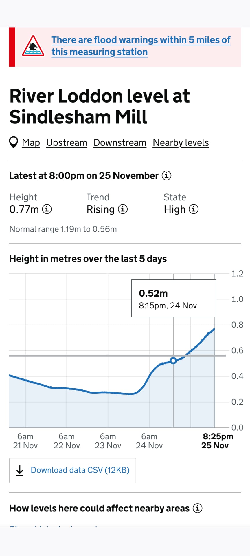
The river depth mentioned here refers to the measurement at Sindlesham Mill, which is the nearest official gauge. Because this gauge is not located within Dinton Pastures itself, the appearance of the river will differ depending on whether the water level is rising or falling.
Sindlesham Mill - the nearest measuring station we have.
Since this is not at Dinton Pastures itself, there will be differences, depending on whether the River is rising or Falling, in how the Loddon looks.
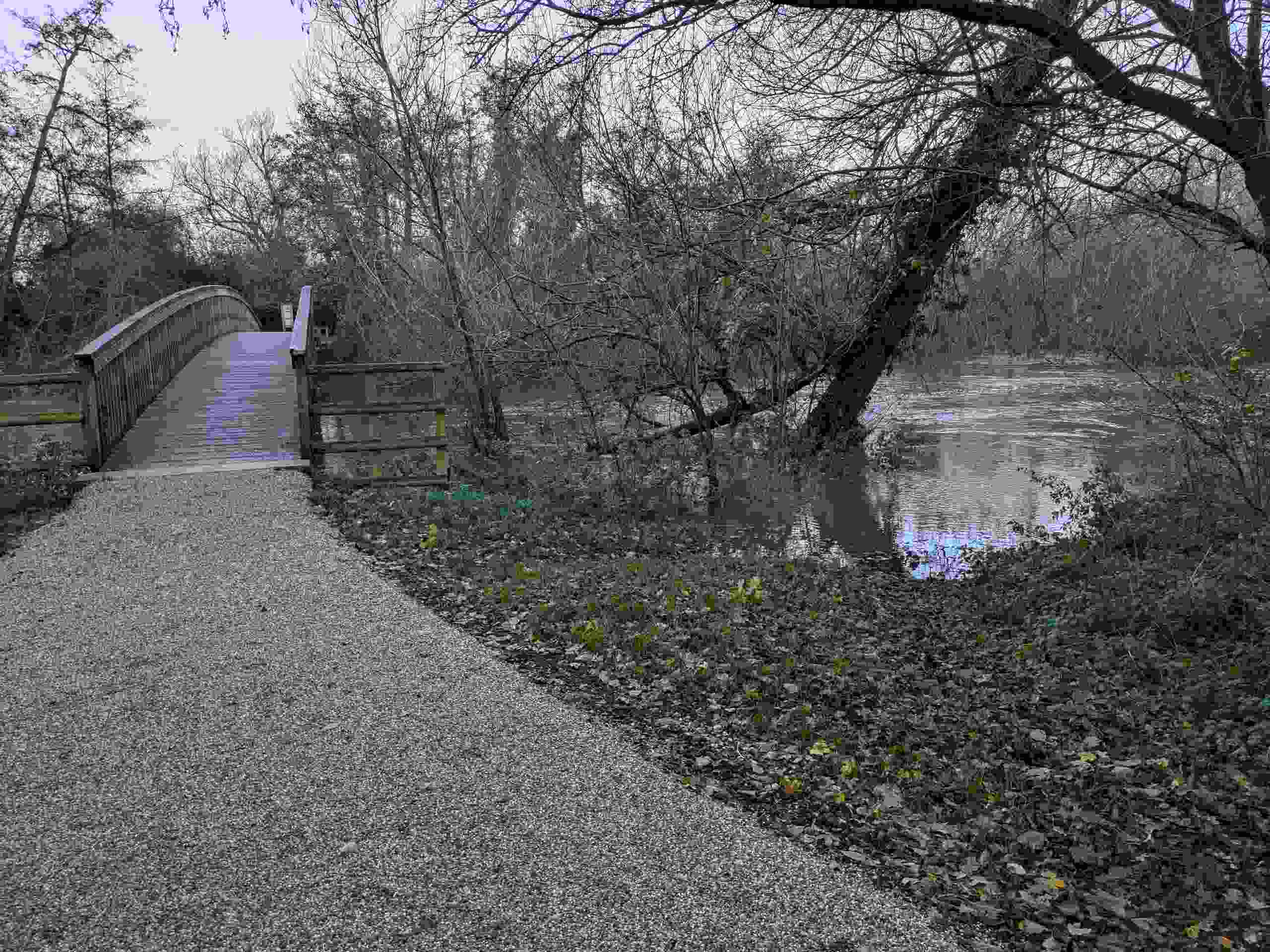
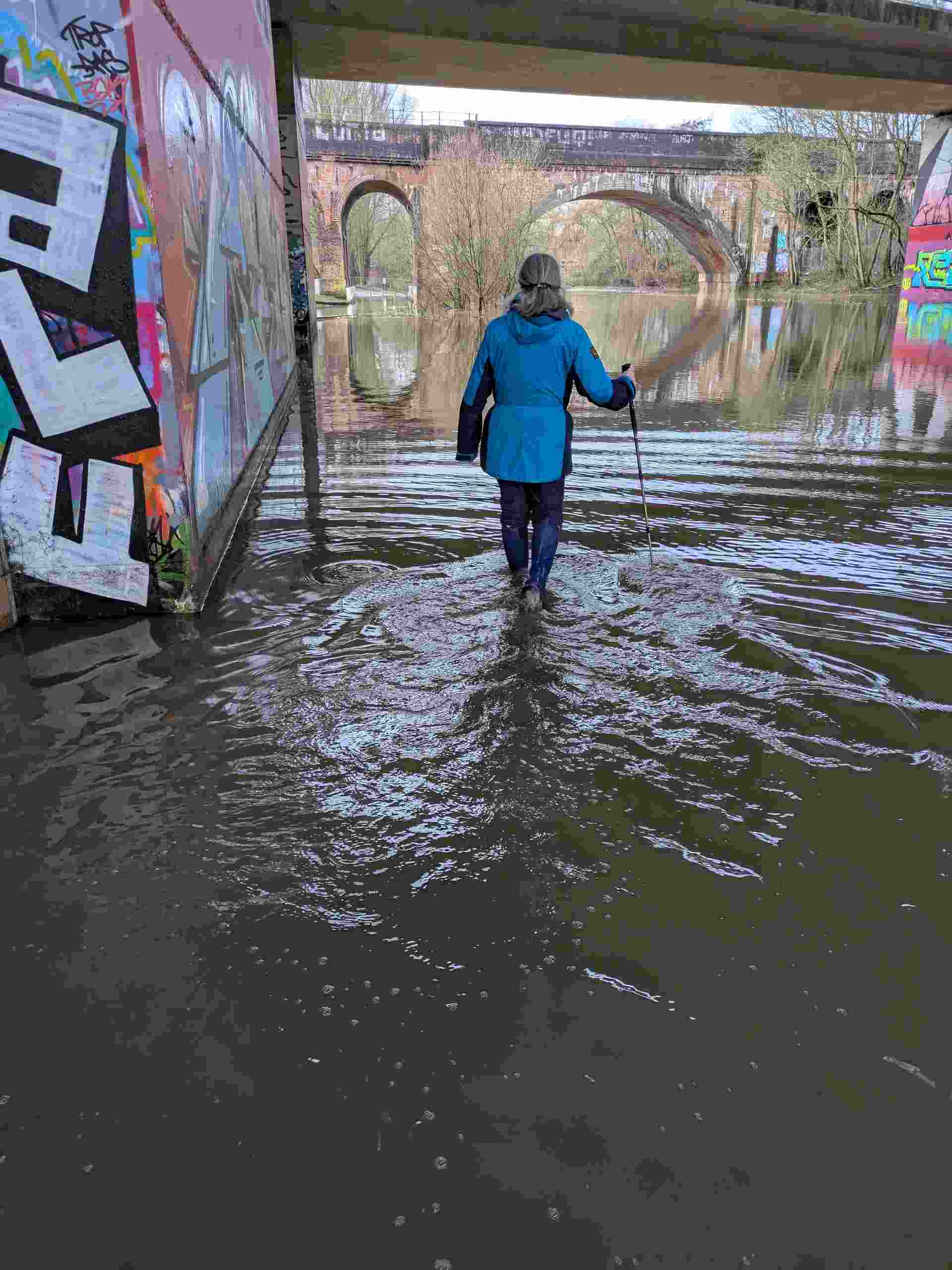
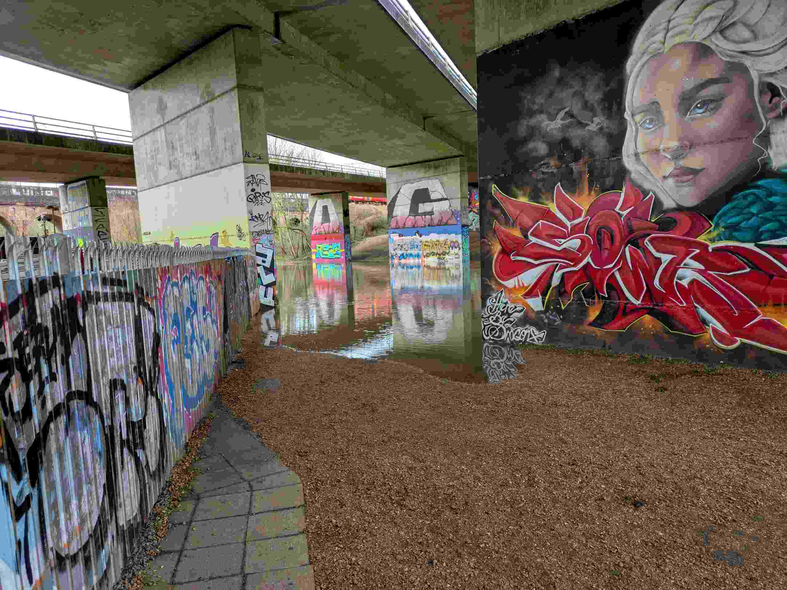
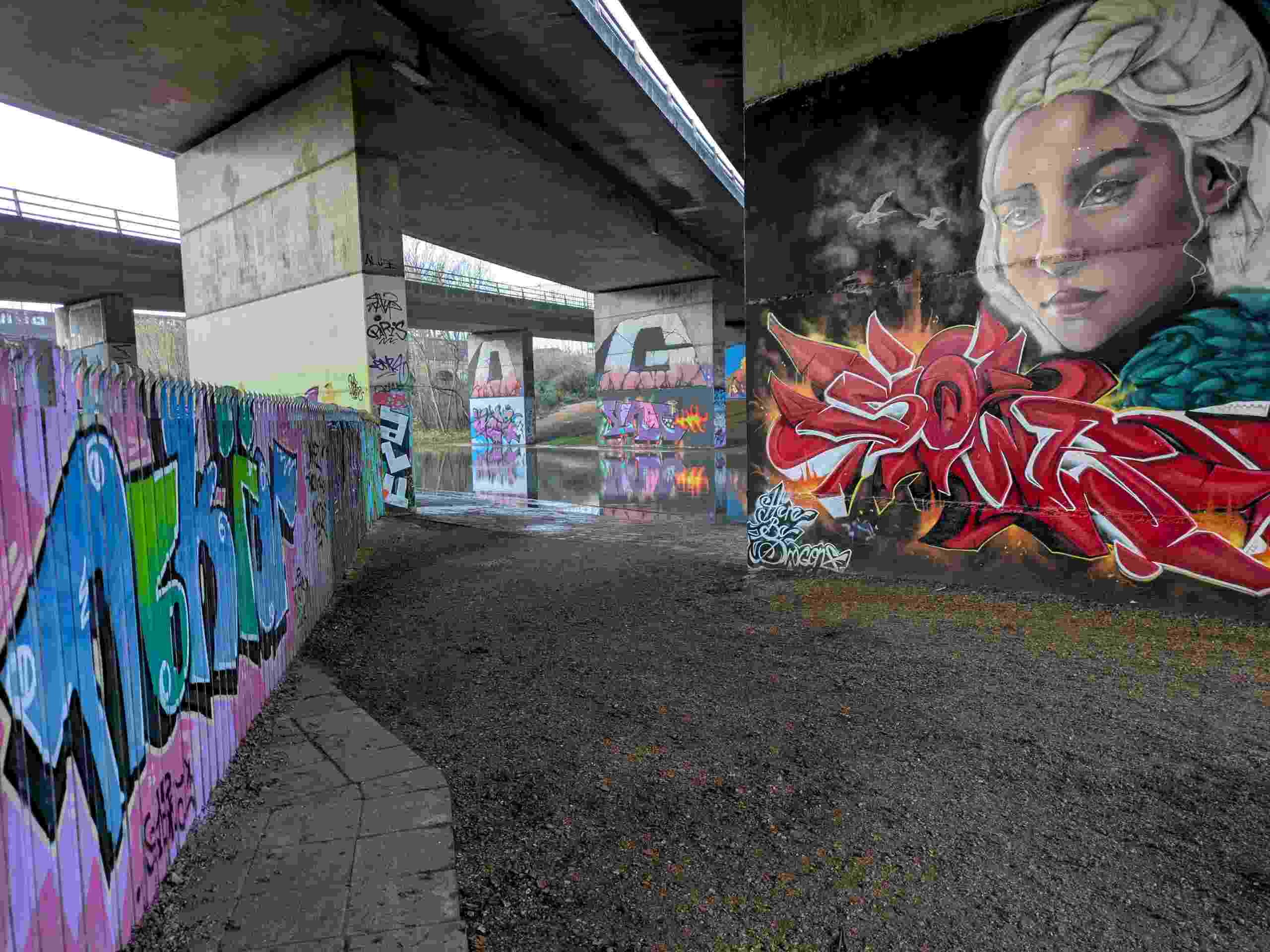
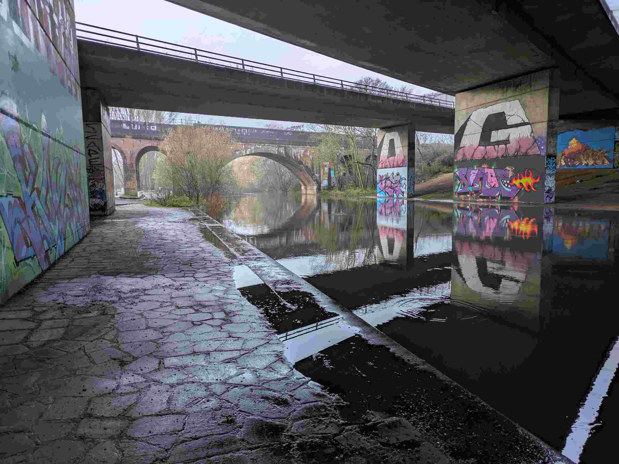
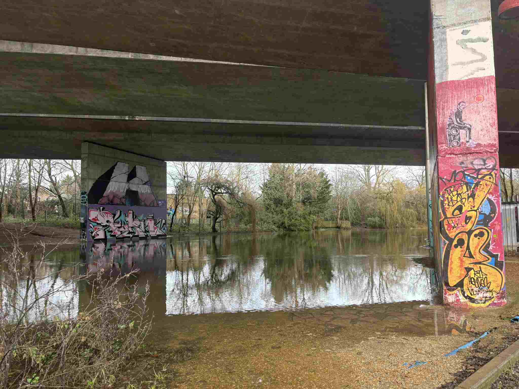
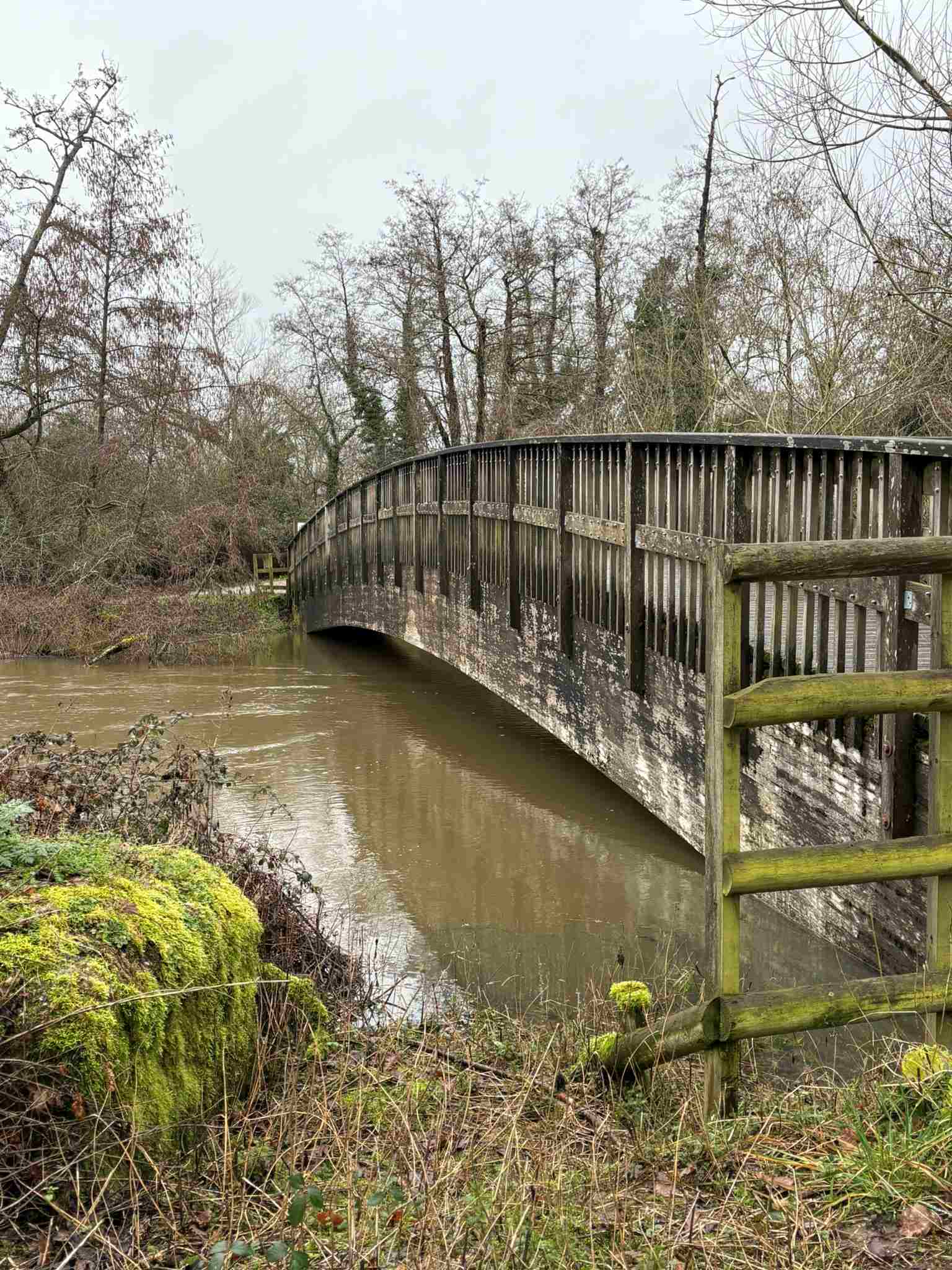
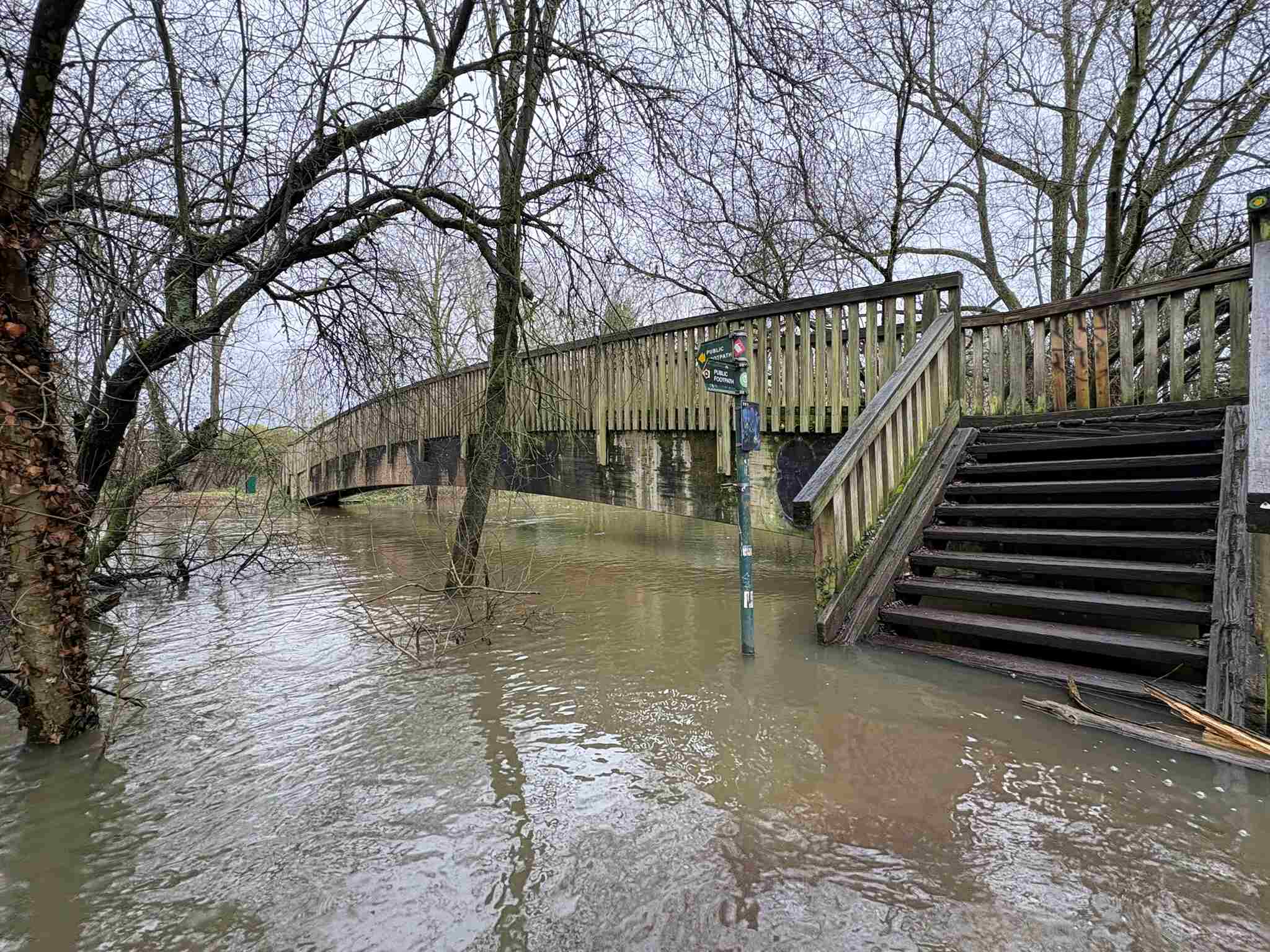
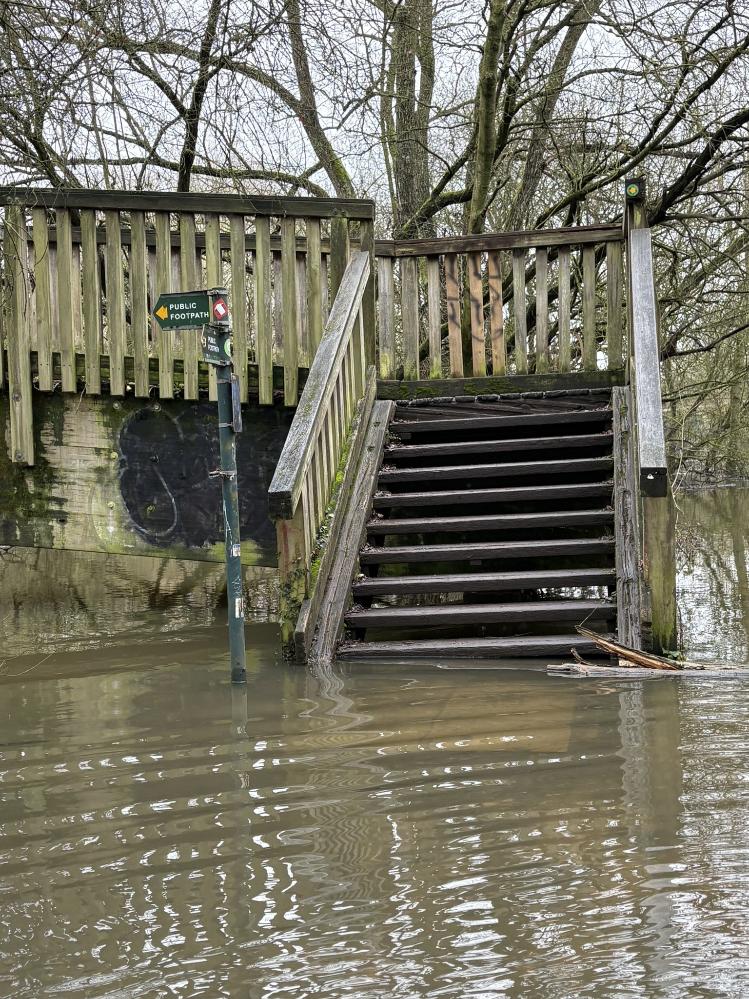
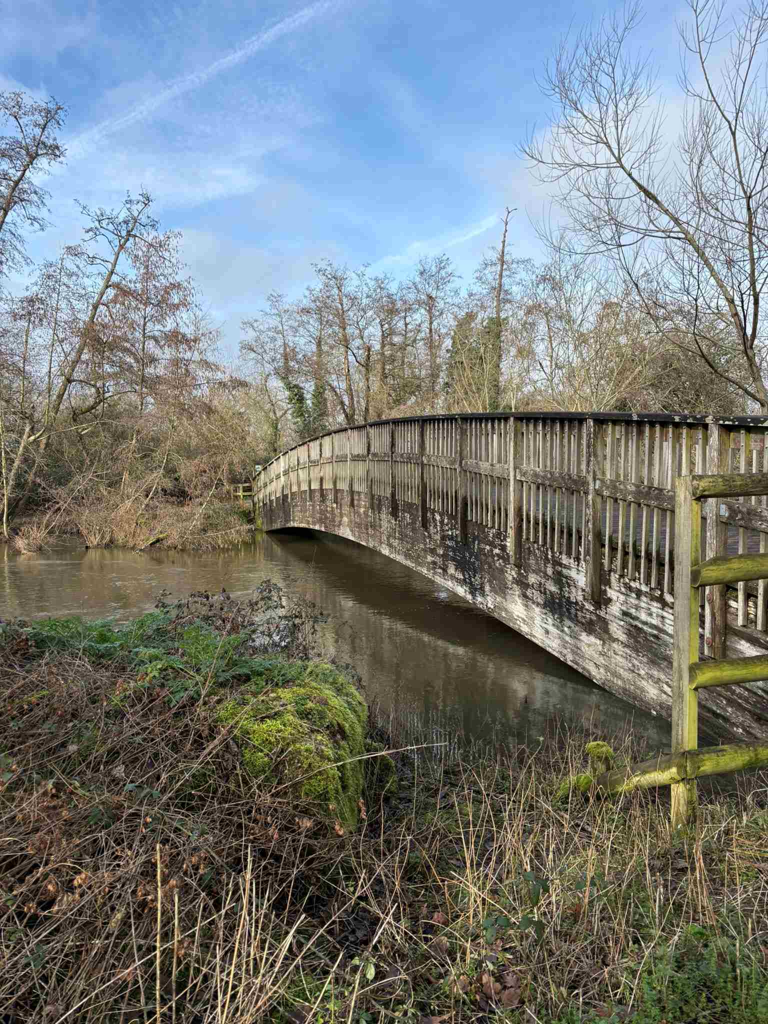
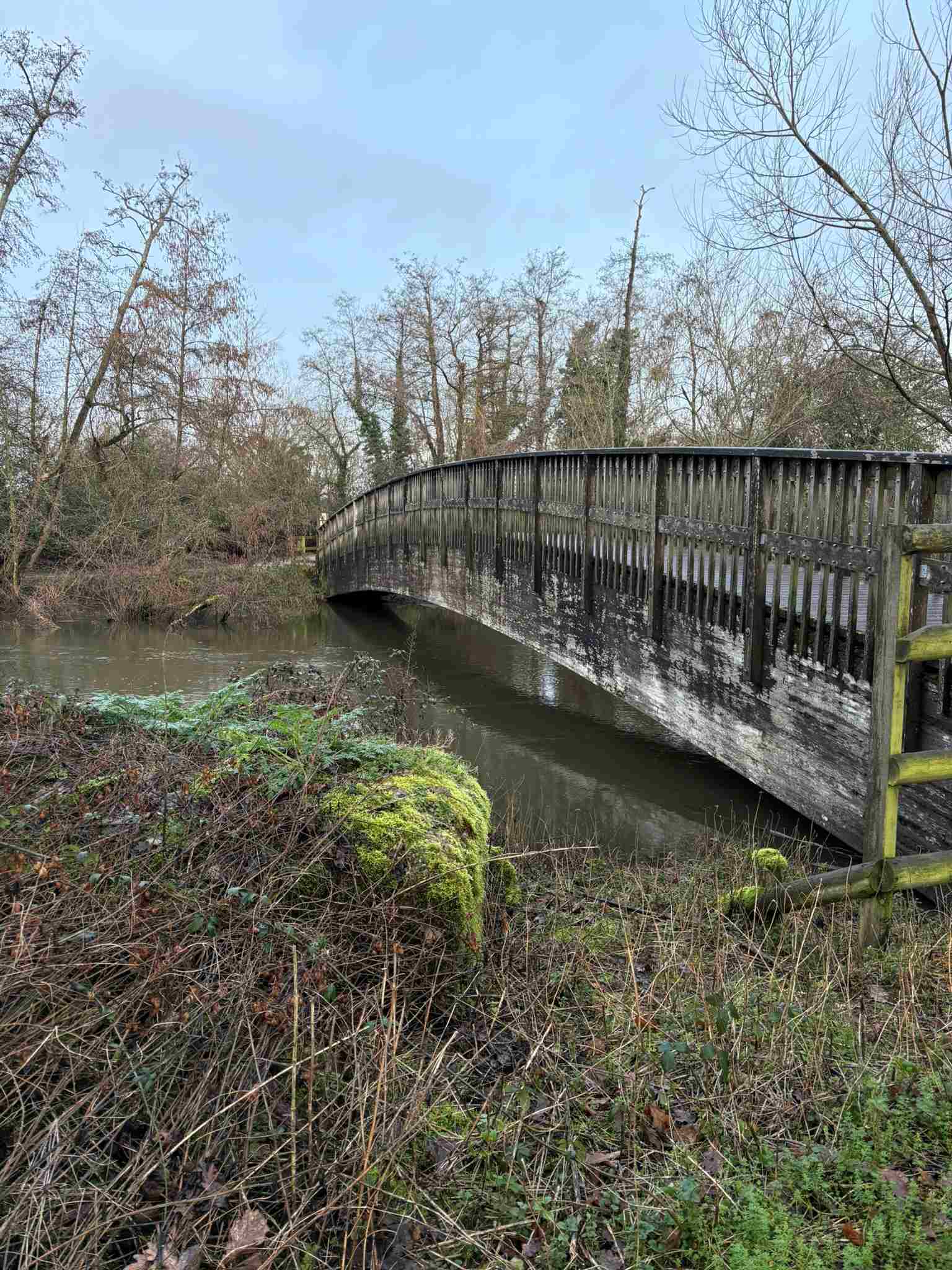
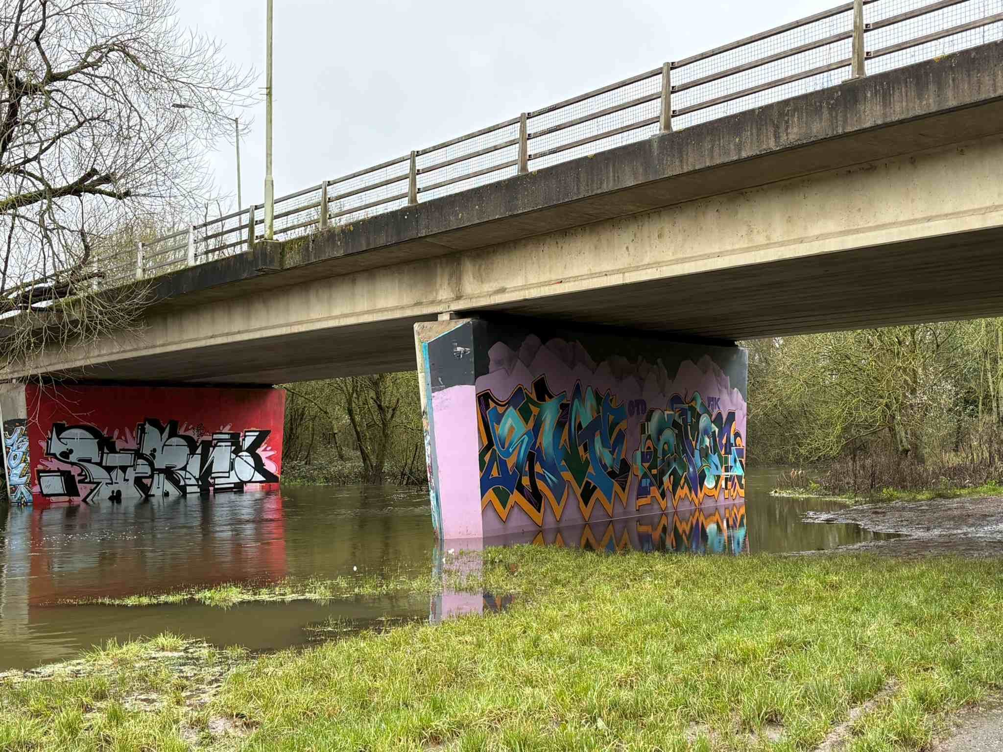
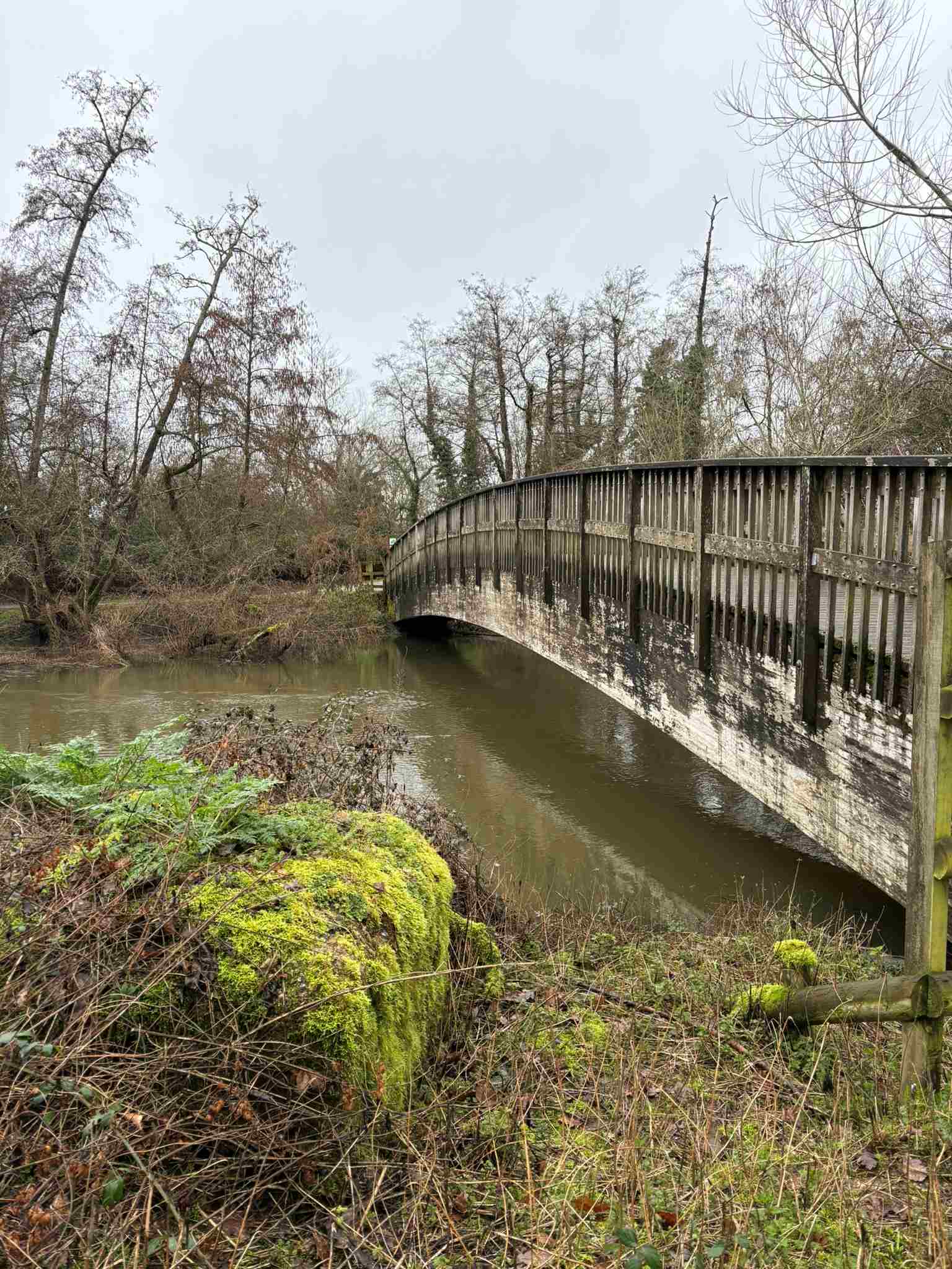
"Mortimer’s Meadow bridge": the arched bridge over the River Loddon connects the path to the White Swan Lake with the paved path on the west bank.
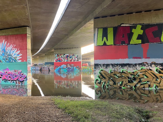
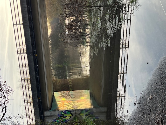
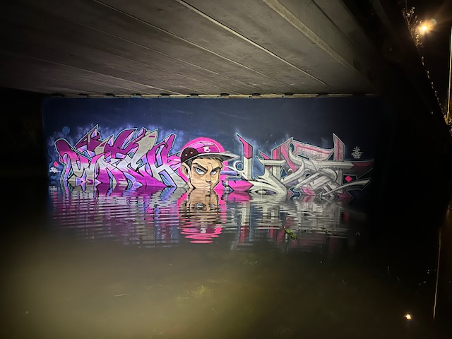
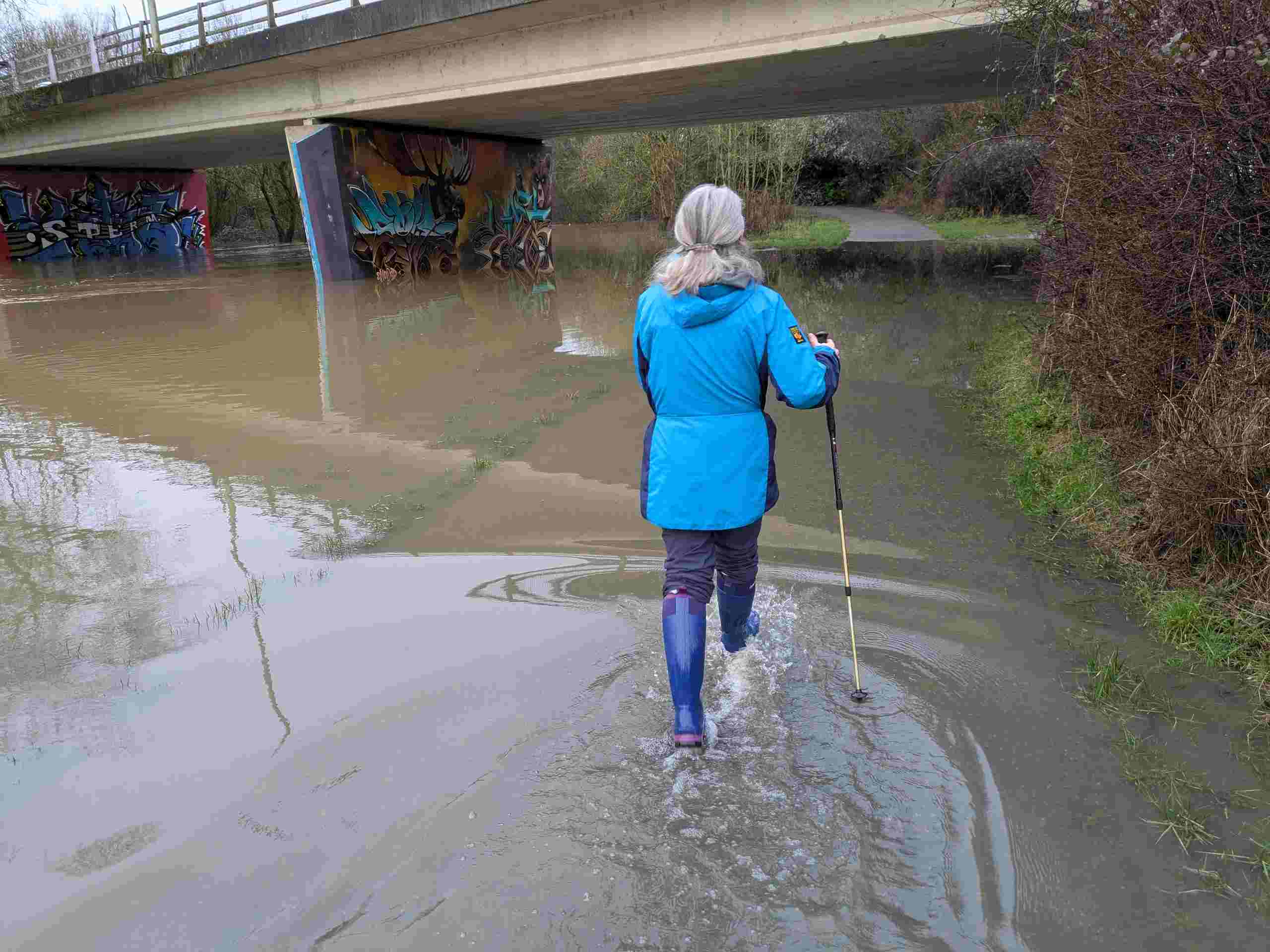
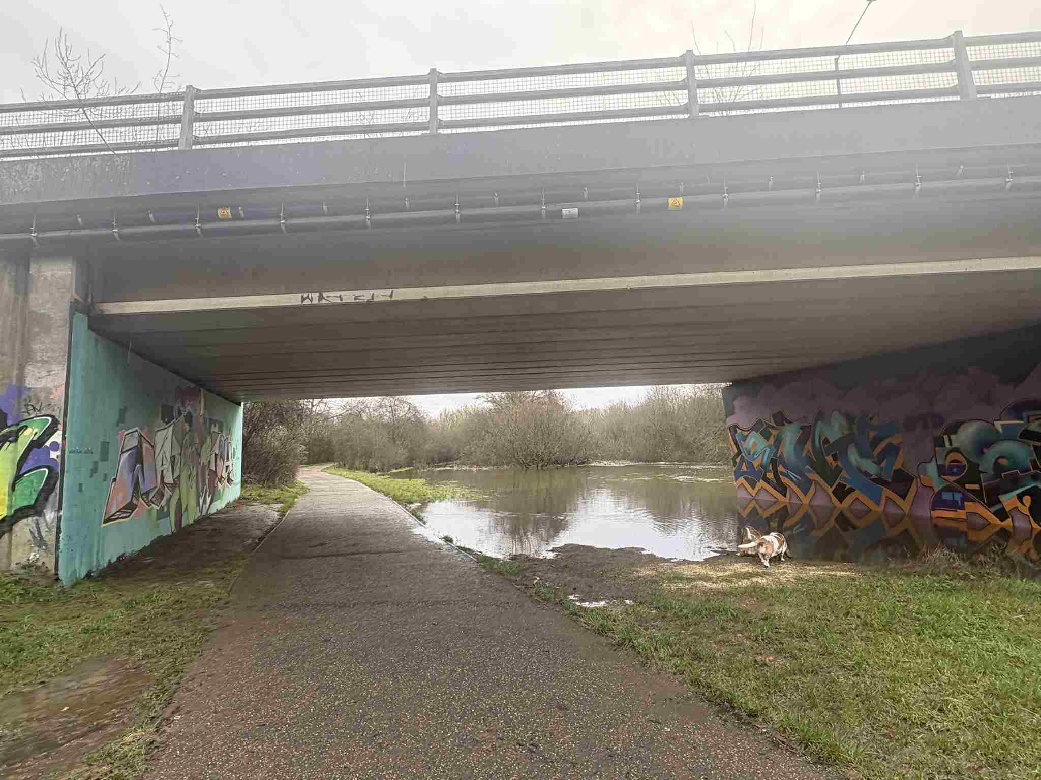
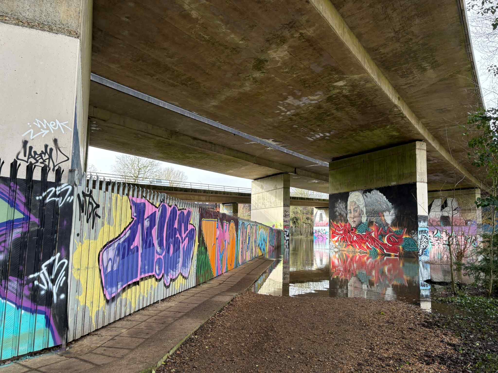
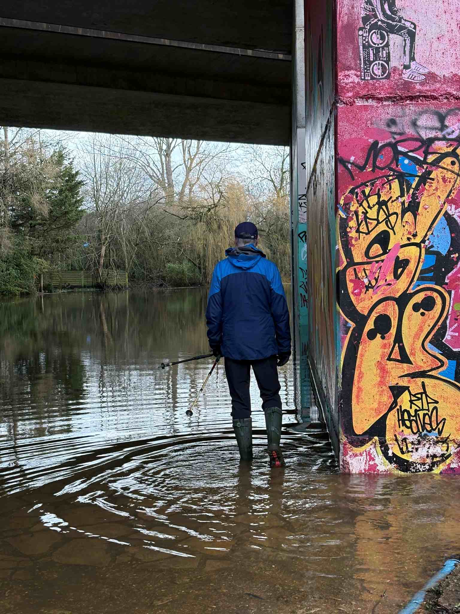
"Bader Way Bridge": appears as an underpass, it's south of the Mortimers' Meadow Bridge and previously had a Star Wars picture, which is handy for comparison and rather good. I think this is the lowest part of my route.
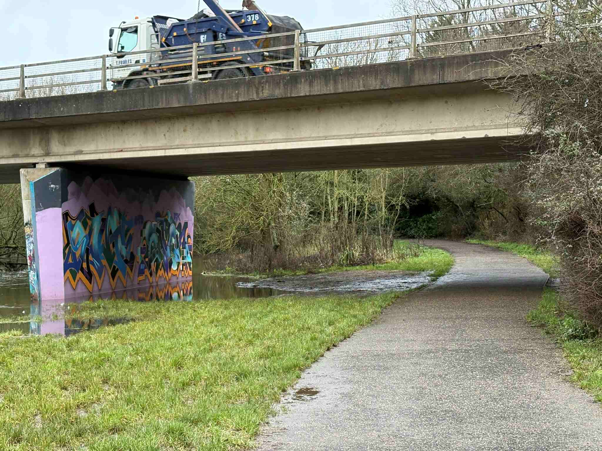
"Colemansmoor Bridge": Located at the entrance on Colemansmoor Road. A wooden bridge south of the Badar Way bridge, where you can cross between the paved path on the west and the mud/gravel path on the east bank.
Water covers the stones beneath the A329M bridge, but a narrow dry strip remains passable. All other parts of the usual route are clear of water. Walking under the Bader Way bridge and along the path is straightforward.
Underthe A329M, there is only a narrow dry path left above the river.
Passable with care in full-height wellies. The lowest point of the route is beneath Bader Way,
where the river has crossed the path. Under the bridge, the path is fully covered, but still
easy to cross in wellies.
Under the Bader Way bridge, the river has gone over the path completely, but can still be passed easily in wellies.
The river level dipped slightly but is rising again, and the ground is fully saturated. Several sections will leave you with wet feet, though the route is still passable in wellies.
Under the Bader Way bridge, the water is particularly high, so wellies are essential. Between the A329M bridge and Colemansmoor bridge, the path is largely submerged and unsurfaced, meaning deep mud beneath a foot of water. A walking stick is useful for checking depth as you go.
.
Approaching Bader Way Bridge from the North - the path goes underwater under the bridge but is passable in wellies.
The path (which is gravel + mud, not tarmac)walking towards the A329M bridge is underwater in places.There is water under the A329M bridge - wellies needed, but it's not too much.
Wellies weren’t enough today, and we didn’t explore much of the path.
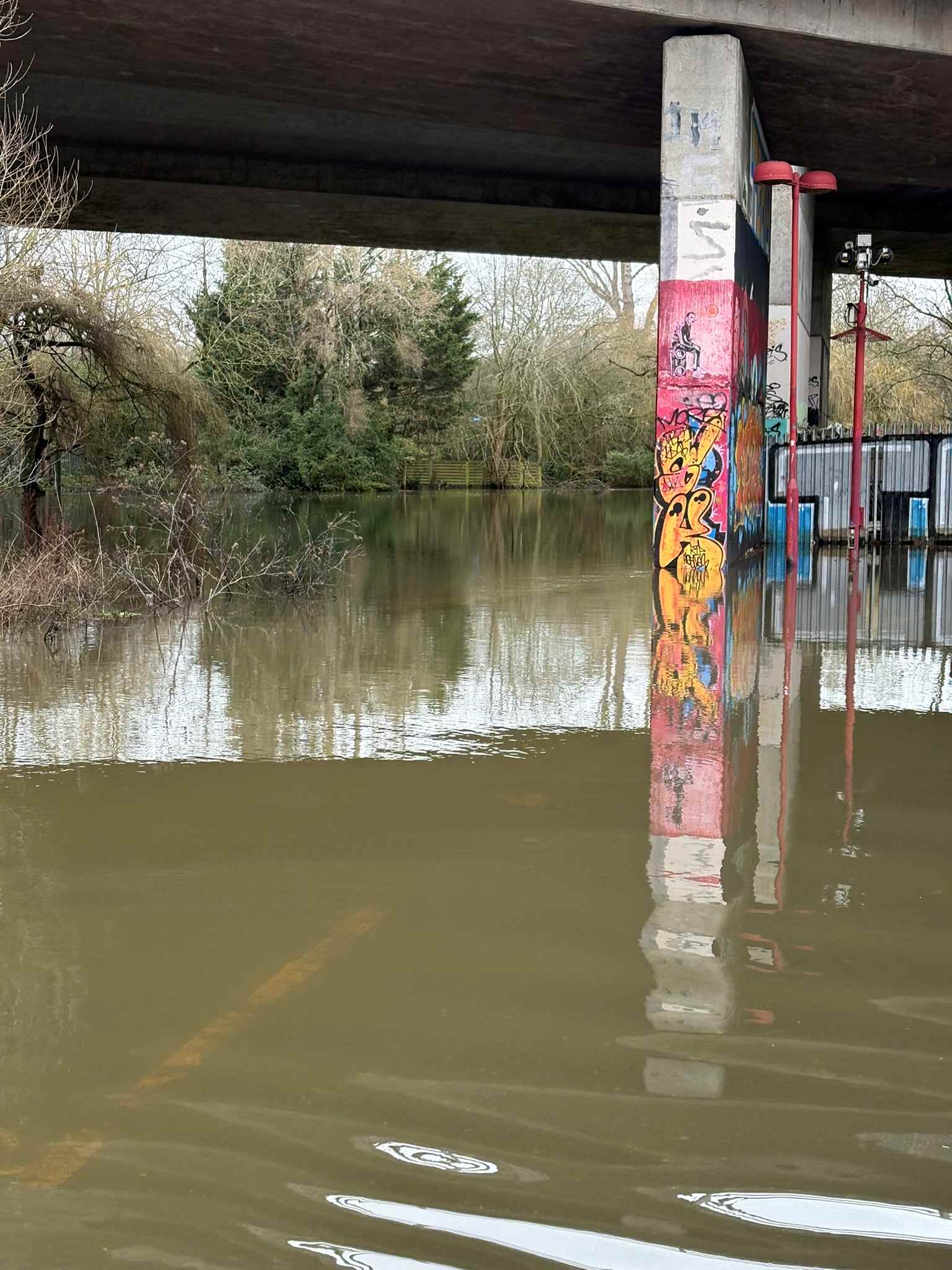
We avoided the usual route entirely as it was clearly submerged. Most of Dinton Pastures was walkable, except for the stretch beside the River Loddon. At the northwest corner of Black Swan Lake, the lake was spilling into a ditch and flowing toward the Emmbrook, but the path was still passable. To the northwest of White Swan, the water alongside the river — and on the approach to it — was deeper than wellie height.
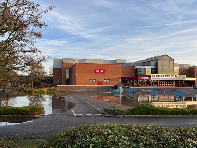
The Showcase Cinema car park was largely underwater, and later in the day, the main roundabout nearby was partially closed.
Screenshot of the Loddon height, showing the height of 1.11m and that we appear to be at the top of a curveMortimers' Meadow Bridge across the River Loddon in flood conditions, only a tiny gap left.
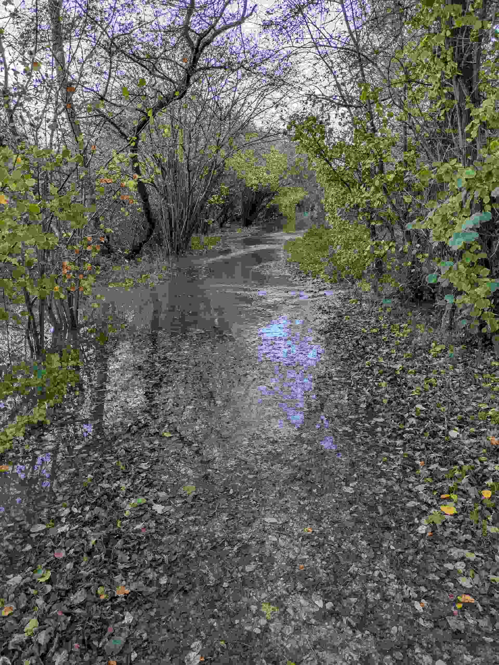
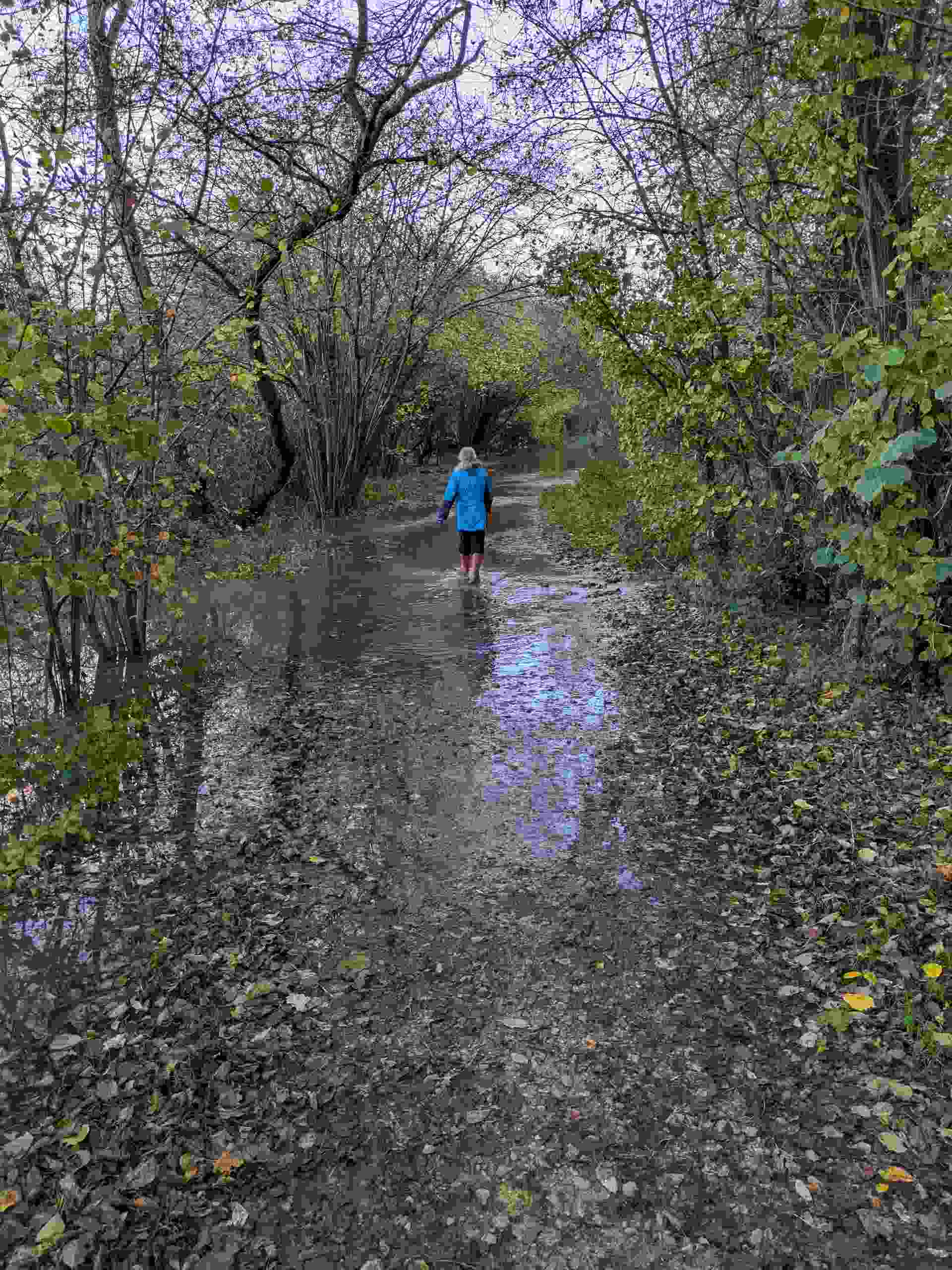
After extensive flooding closed the path, the water levels are now falling, and the route is usable again. Wellies or ankle-length hiking boots are still advisable, and a bit of care is needed.
The water has recently been so high that it is now draining back into the river from the meadow between the Mortimers' Bridge and the Bader Way Bridge. Because of this, wellies are more necessary than the apparent depth might suggest.
Screenshot of the Loddon height, showing recent changes and that it is falling.The path is still under some water following floods
After large amounts of flooding closed the path, the waters are now dropping, and the path can be used. Either wellies or hiking boots, and some care is needed.
The water has been so high recently that it is now running back into the river from the Mortimers' Meadow on the section of path between the Mortimers' Meadow bridge and the Bader Way Bridge, so wellies are required more than the depth implies.
Screenshot of the Loddon height, showing recent changes and that it is falling.The path is still under some water following floods.
After several weeks with the river sitting below the high water line at Sindlesham, levels are rising again following a couple of days of rain. It has just overtopped the path under the Bader Way bridge.
The path I use is still completely above water.
What’s notable today is that the water has crept onto the grass by about a centimetre, so I’m recording that 0.54 m is the first depth at which the grass starts to get damp.
River under Bader Way bridge reaches the Star Wars Mural.
The water is rising quickly at the moment, but the paths themselves are still clear of the River Loddon. Some sections alongside the river are covered by deep puddles from the overnight rain, though this is surface water rather than river flooding..
The narrow path above the river under the A329M bridge remains passable, but the puddles there definitely call for waterproof footwear.
Graph showing Loddon height rising steeply.Around the Bader Way Bridge.Around the Bader Way Bridge.Around Mortimers' Meadow bridge across the River Loddon.View from the Colemansmoor Road wooden bridge.Under the A329M bridge.
Water is rising quickly at this point, but the paths are still not under the River Loddon.Narrow path above the river under the A329M bridge, but puddles require waterproof footwear.
Under A329M path clear.Under the Bader Way Bridge, showing the paths are clear.
The water is rising quickly now, and the paths are starting to go under as the River Loddon overtops its banks. Care will need to be taken as levels continue to climb.
Graph showing Loddon height rising steeply.Around the Bader Way Bridge towards Star Wars imageUnder the Bader Way Bridge showing depth over my feet.
Water has been rising quickly since yesterday morning. The Sindlesham Mill gauge is reading 0.85, which we had assumed would make the route impassable, so we didn’t plan to attempt the full walk. It’s useful having my photos here to compare conditions.
Coming from the main Dinton area and crossing the Mortimers' Meadow bridge, we didn’t get far before encountering fast‑flowing water running over the path. It appeared to be draining off the meadows — likely leaving near the Bader Way bridge and re‑joining the river at this point.
Graph showing Loddon height rising steeply, though only at 0.52 meters when we visited.Under the Bader Way Bridge, barely out of its banks.Under the Bader Way Bridge, barely out of its banks, seen from a slight distance.
Water has been rising quickly since yesterday morning. The Sindlesham Mill gauge shows 0.85, which we expected to be unpassable, so we did not plan to walk the full usual route. It's handy having my pictures here to check against.
Approaching from Dinton main area, over the Mortimer Meadow bridge, we didn't go very far till the water was flowing quickly over the path (into the river - so it was leaving probably by the Bader Way bridge and flowing over the meadows to re-join here.
Graph showing Loddon height is very high at 0.86 meters when we visited.Water is getting close to the Mortimers' Meadow Bridge.Not far from the Mortimers' Meadow Bridge, moving towards the Bader Way Bridge, the path becomes underwater with an obvious flow.The flow was obvious at this stretch, and we decided based on that, and the river level readings, not to continue.
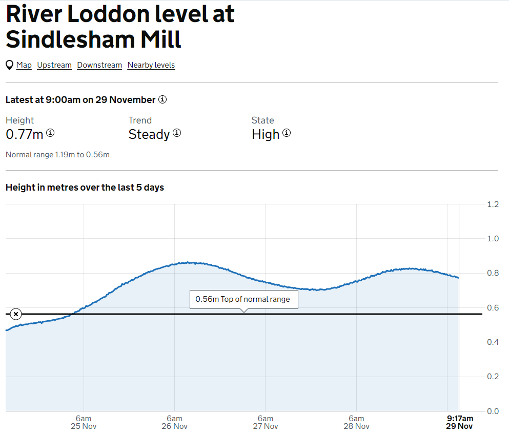
The river height recently started dropping since reaching a high (about 9 pm last night). The Sindlesham Mill gauge shows 0.77 around the time of these images.
We didn't expect this river to be passable and took some photos from different locations as usual - the walk was to another place today anyway.
Approaching from the Showcase Cinema towards Dinton main area, we were first wading under the A329M just beside the cinema car park. The water came to within 5 or so cm of the top of adult wellies.
The water height at Sindlesham Mill was at graph. The water at 9:00 a.m. was 0.77m, the time of this walk.Showcase carpark showing current state of flooding.The fence in the distance is next to the usual footpath we use, which is submerged, then the red-painted pillar is at the other side of the river and the water continues towards us here.Under the Bader Way bridge from a bit further back than usual, showing the spread of the water that is flowing across the path and into the meadows..
The river level has been dropping throughout the day. The Sindlesham Mill gauge is reading 0.73, which we expected would be passable only in wellies, so we set out after dark for an evening check.
Approaching from the Showcase Cinema towards Dinton main area, we were first wading under the A329M just beside the cinema car park. The water came to within 5 or so cm of the top of adult wellies.
The water height at Sindlesham Mill was at graph. At 5:15 pm was 0.73m, the time of this walk, though it had dropped to 0.70 by the time this photo was takenUnder the A329M bridge. Wading only fills adult wellies.We waded from the A329M bridge towards the bridge over near Colemansmoor Road.Some of the central section was dry, but we were wading again by the time we reached the bridge.This is the old Star Wars bridge. Bader Way Bridge is underwater and required adult wellies in the past.
The river height has been climbing for a while. The Sindlesham Mill gauge shows 0.75, which we expected to be passable only in wellies, but the water was not as high as expected.
I imagine this is because it is climbing fast and will soon be much higher based on other readings I've collected here.
Coming from Dinton Pastures and crossing the Mortimer Meadow bridge, we encountered only a few puddles before reaching the Bader Way bridge. Even there, the water barely rose over the feet of our wellies.
The gauge at Sindlesham Mill recorded a water level of 0.75 m at 7:20 pm, the time of this walk, with levels increasing quickly.Bader Way Bridge is underwater with water just over ankle height.Bader Way Bridge is underwater, only a small problem for walkers in Wellington boots.Under the A329M bridge. Passable in wellies - just over the feet..The water is well over the A329M, but only just over the feet.
The river level peaked overnight and is now falling at Sindlesham, with levels at Dinton Pastures likely just beginning to drop as well. The Sindlesham Mill gauge is currently reading 0.56 m, only slightly above normal. The river is just over its banks in a few places but has not reached any of the footpaths.
Happy Solstice. On the shortest day of the year, the river is finally rising again after a long, drought-heavy summer.
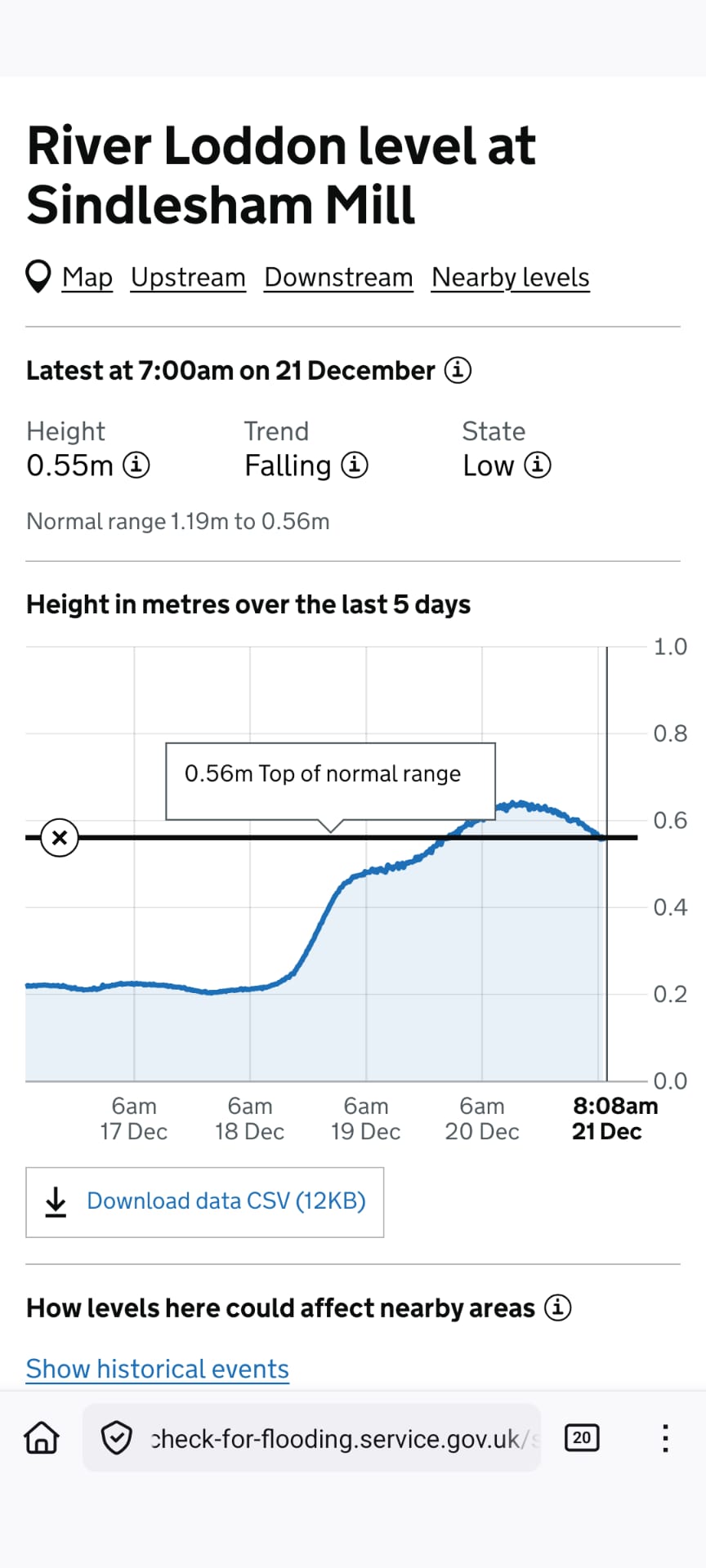
At the time of this walk (8:08 am), the Sindlesham Mill gauge showed a water level of 0.56 m and was falling slowly. There was a brief overnight rise, peaking at 0.64 m at 11:15 am on the 20th, but levels have since dropped back to the top of the normal range. A similar pattern is expected here, although the decrease may be slightly slower.
The water height at Sindlesham Mill This is the old Star Wars bridge. Under the Bader Way Bridge, the water is over the bank a little, but some distance from the path.Under the A329M approaching the River Loddon.Under the A329M bridge. The River Loddon is starting to spill over the bank, the path remains clear.
The river height peaked overnight and is falling at Sindlesham, probably just starting to fall near Dinton Pastures now. The Sindlesham Mill gauge shows 0.56, which is only a small amount over "normal", so it's only just above banks in a few places and not reached any paths.
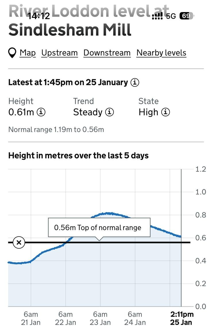
The water height at Sindlesham Mill was at graph shows water at 14.14 (2.14 pm) was 0.61m, the time of this walk - and falling slowly. There has been a "bump" over the last few days, so there is a lot of standing water from when the water was higher.Under the A329M bridge, showing that there is only a narrow strip of ground not yet flooded.
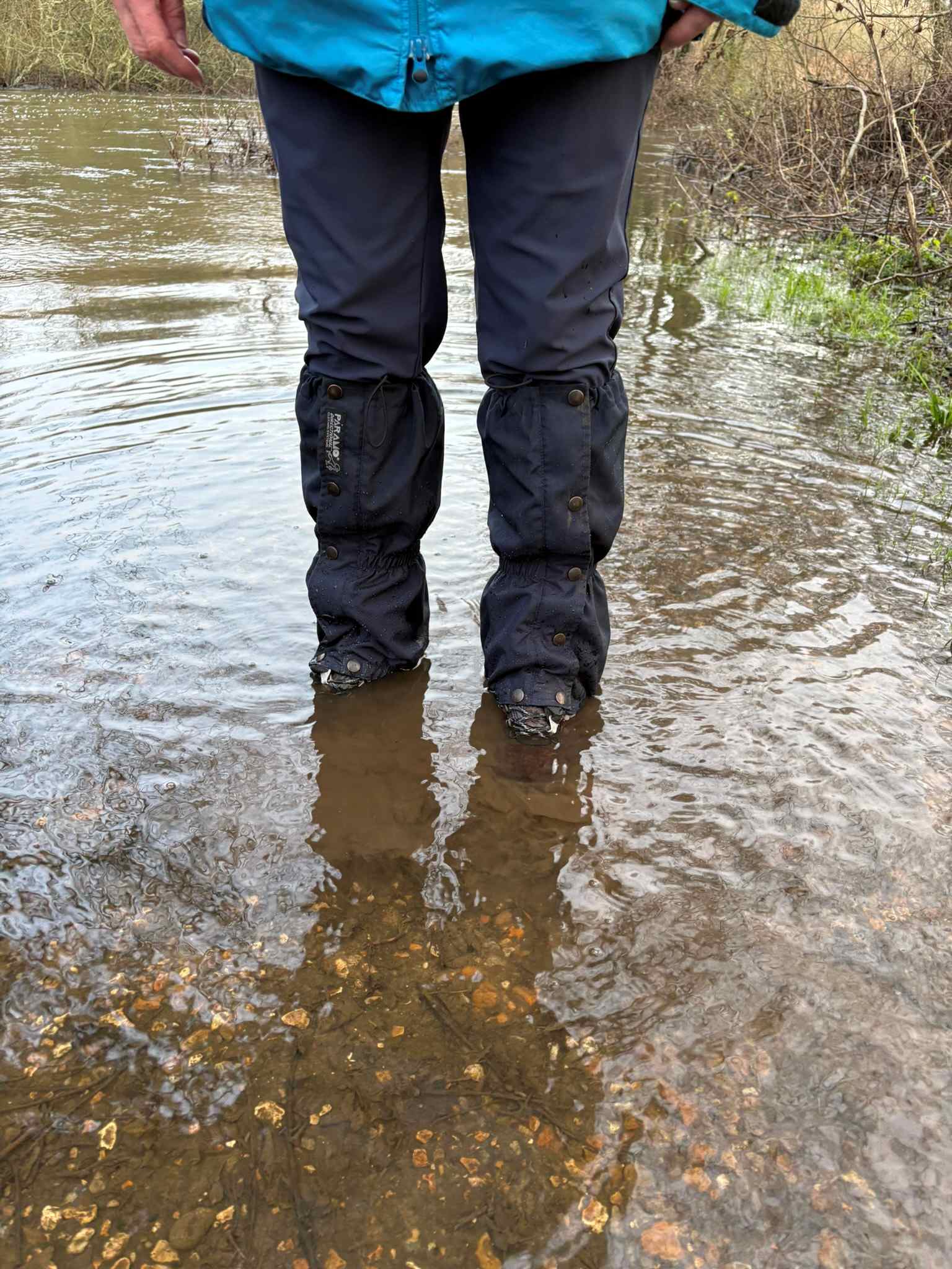
The river levels rose overnight at Sindlesham and are continuing to rise steadily at Dinton Pastures. The Sindlesham Mill gauge is currently reading 0.78m. Paths along the riverbanks at Dinton were flooded, and extra care was required. Full-height Wellington boots and a walking stick were necessary to safely check the depth of water on the paths.
The path in places is currently submerged, with water beginning to flow in from adjacent fields. Conditions are not suitable for cyclists unless they are able to pedal continuously. Extra care is required when moving through standing water.
The graph showing the water height at Sindlesham Mill. At 3:15 pm, the water was 0.76m and was rising steadily.Under the A325M, the path is underwater.Under the A329M, a view towards the path. The water has started to encroach on the Showcase Cinema carpark. The path beneath the Bader Way bridge is currently submerged.
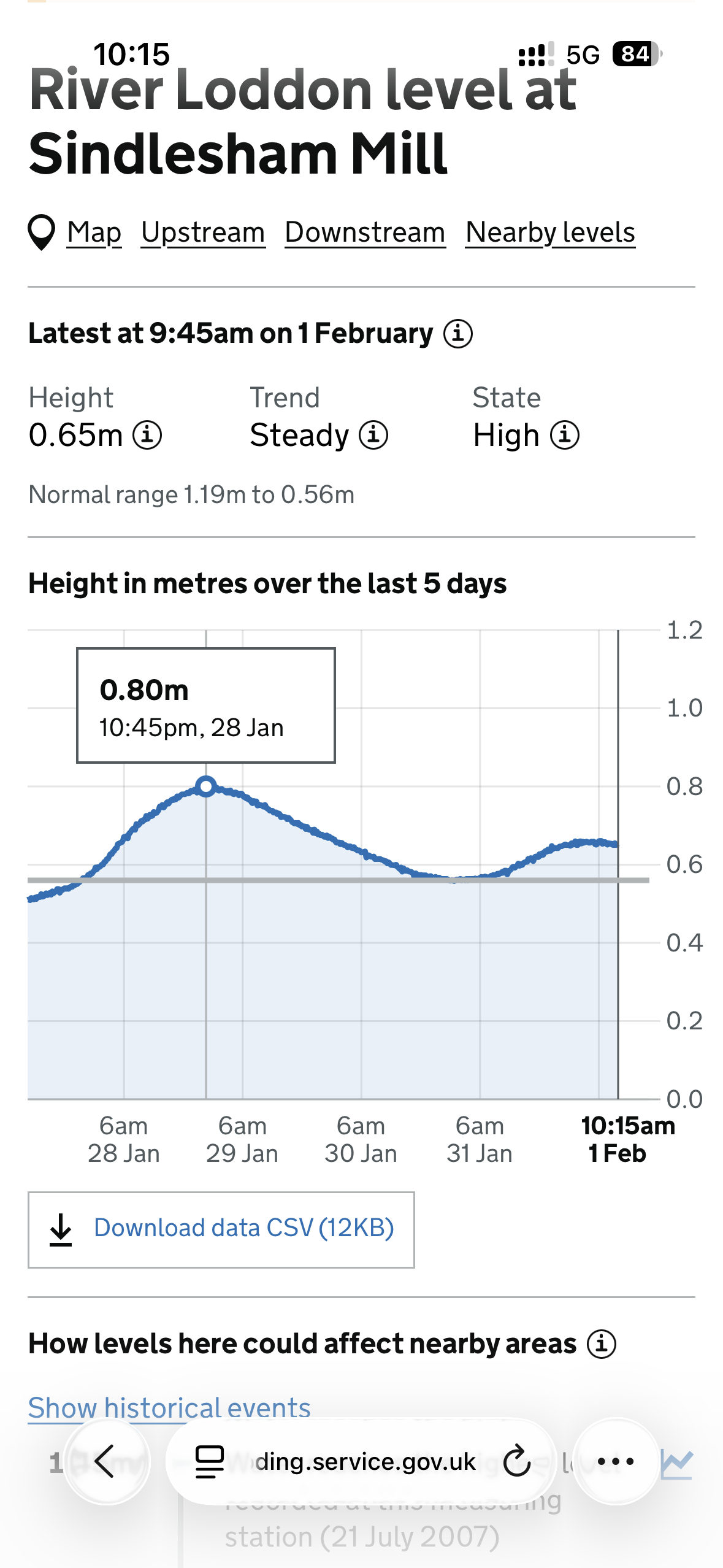
The river levels have been rising over the past few hours and continue to increase steadily at Dinton Pastures. The Sindlesham Mill gauge is currently reading 0.65 m. Sections of the riverbank paths in Dinton were flooded. The path under the A329M near the cinema was flooded and required walking boots or wellies, with water reaching just above ankle height in places. Surprisingly, the path under the Bader Way bridge remained clear.
The graph showing the water height at Sindlesham Mill. At 9.45 am, the water was 0.65m and was steady.Under the A325M, the path is underwater, so wellies or walking boots are needed.The path under the Bader Way Bridge is clearA view across to Mortimers Meadow arched bridge across the River Loddon.
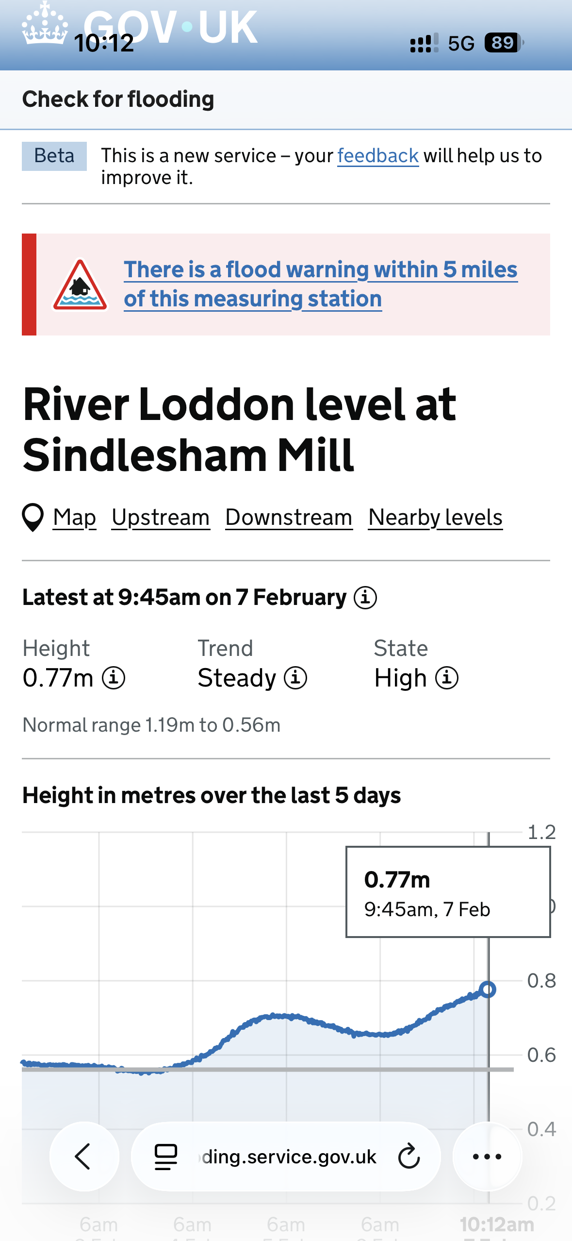
River levels have been gradually rising over the past few hours, with the Sindlesham Mill gauge now reading 0.77. Several sections of the riverbank paths in Dinton are currently flooded. The path beneath the A329M is underwater, as are parts of the cinema car park. Wellies are essential—at times, the water was deep enough to spill over the tops. My walking stick was useful for navigating the route and locating slightly higher ground to step on.
The path beside the Loddon, from the A329M bridge to the Colemansmoor bridge, had some particularly deep stretches. Under the Bader Way bridge, water was flowing strongly across the path toward Mortimer Meadows. Walking towards the Mortimers' meadow bridge, the water was at wellie height in parts. The conditions were not suitable for cyclists or people in low shoes.
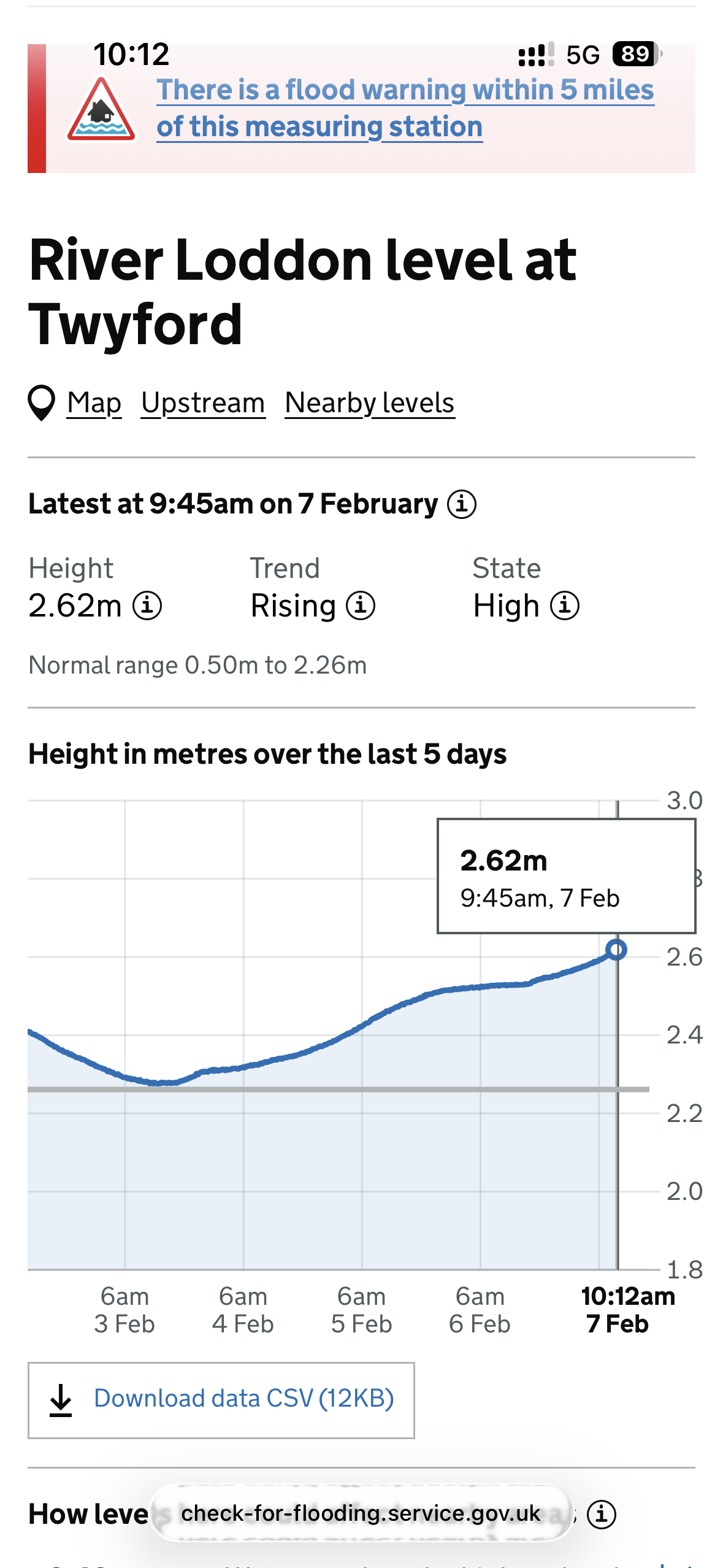
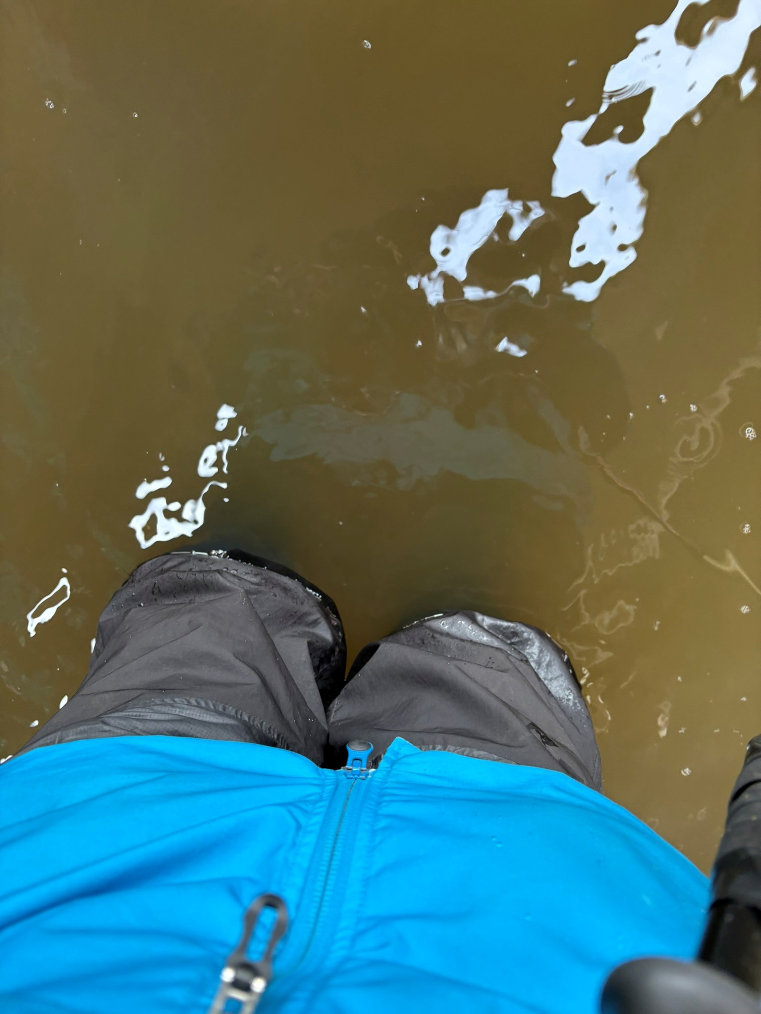
The graph showing the water height at Sindlesham Mill. At 9.45 am, the water was 0.77m and was rising.The graph showing the water height at Twyford. At 9.45 am, the water was 2.62m and was rising.Walking towards the Bader Way bridge from the Mortimers' Meadow bridge, long stretches of the path are under water, some places at wellie height.A view across to Mortimers' Meadow arched bridge across the River Loddon.A photo of my wellies showing how deep the water is beneath the Bader Way bridge.The path underneath the A329m is underwater and in parts deep.A view across the River Loddon from the Colemansmoor bridge, the path is under water at wellie height in parts.A view across the River Loddon from the Bader Way Bridge.
The River Loddon dropped very slightly overnight. When walking the paths, this change is barely noticeable, and there is still extensive flooding. Entering from the Showcase Cinema car park and walking under the A329M bridge, the water level is marginally lower, sitting just below the top of wellington boots.
Towards Colemansmoor Bridge, there are large puddles in front of the steps up to the bridge and along the path. After crossing the bridge and continuing onto the Bader Way bridge, full-height wellingtons are still required to go under the bridge.
Approaching the Mortimers’ Meadow bridge, large sections of the path remain underwater. Extra care is needed, and using a walking stick is recommended to check the ground while walking.
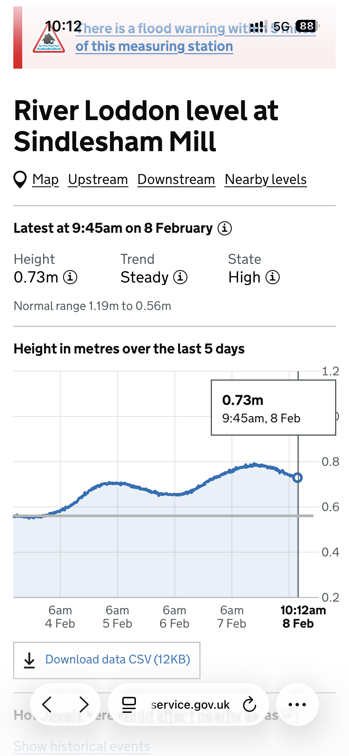
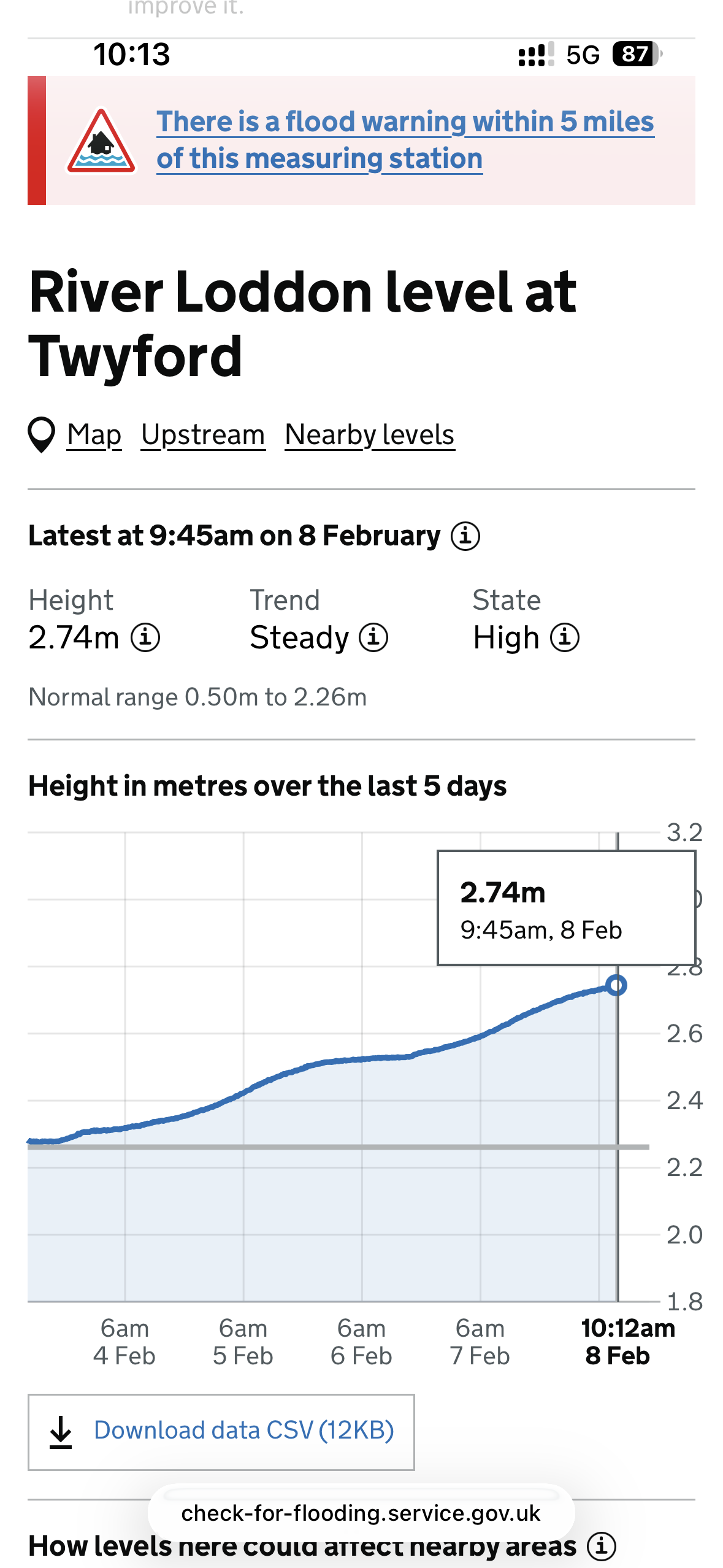
The graph showing the water height at Sindlesham Mill. At 9.45 am, the
water was 0.73m and was steady.The graph showing the water height at Twyford At 9.45 am, the water was 2.74m and was steady.Approaching Colemansmoor Bridge from the A329M bridge, the path is still underwater and deep in placesThe path beneath the A329M bridge is still flooded.A view across to the Mortimers' Meadow bridge. Flooding continues under Bader Way, with water over halfway up our wellington boots.
Water levels have gone down very slowly overnight. Choosing between walking boots and wellies was something of a gamble, so one of us opted for wellies while the other wore walking boots with long gaiters.
On approaching the footpath beneath the A329M bridge, the path is flooded, with water reaching ankle height in places on my walking boots. Slow walking here to reduce water movement.
Continuing towards Colemansmoor Bridge, the path is mostly clear, although there are several large puddles. The steps up to the bridge are dry and passable.The path beneath the Bader Way Bridge is also flooded. The water was slightly shallower than expected and passable in walking boots.From Bader Way Bridge to Mortimer’s Meadow Bridge, the path is largely clear, apart from one large, deep puddle. This is not connected to the river but is caused by water flowing back from the meadows into the river. Without long gaiters, this section would have been difficult to cross in walking boots—wellies were the better option here.
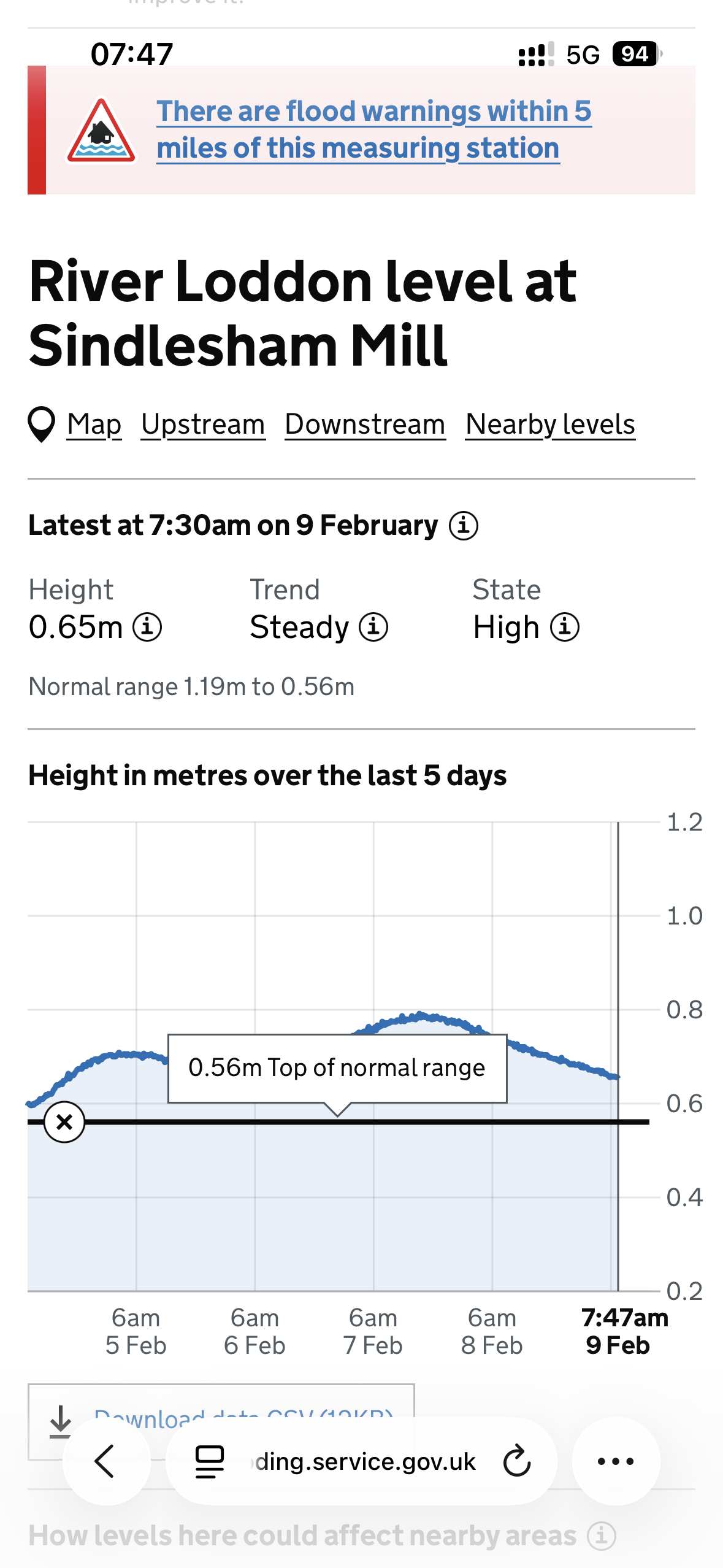
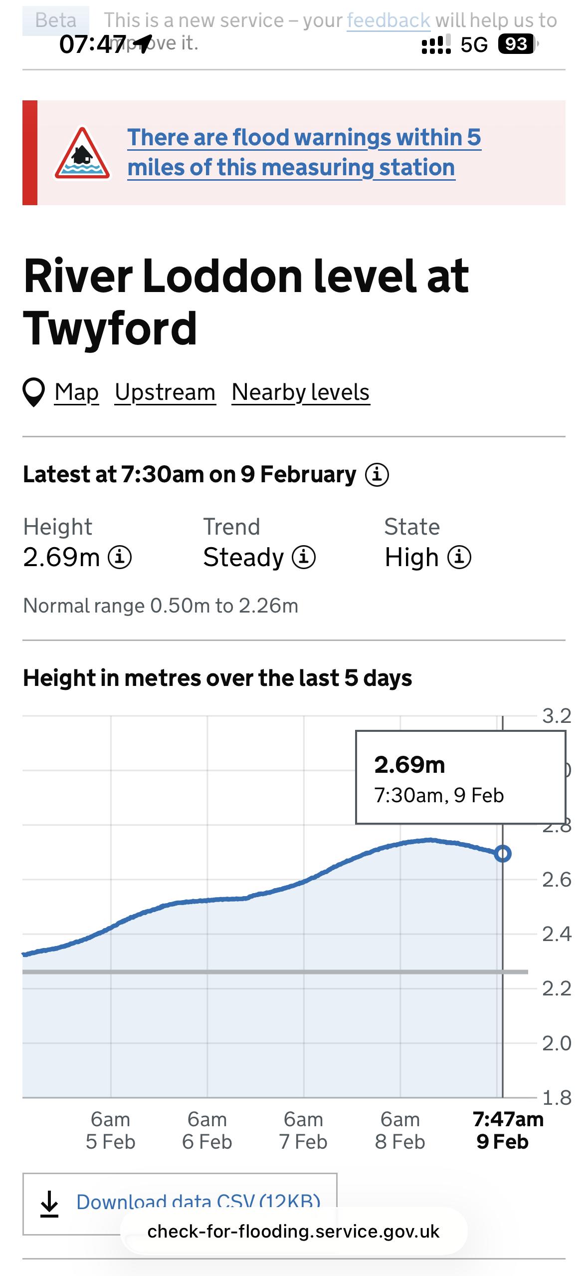
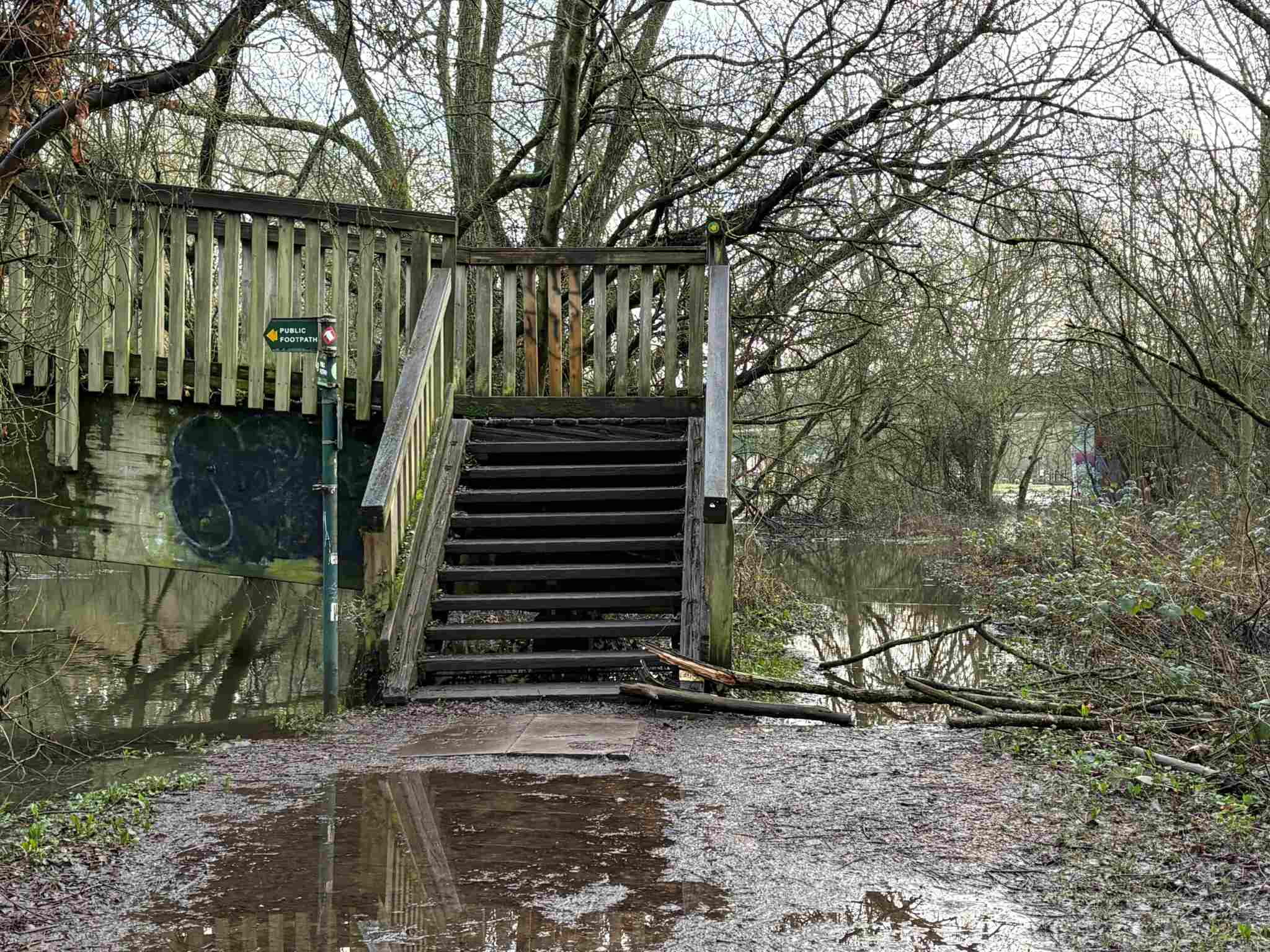
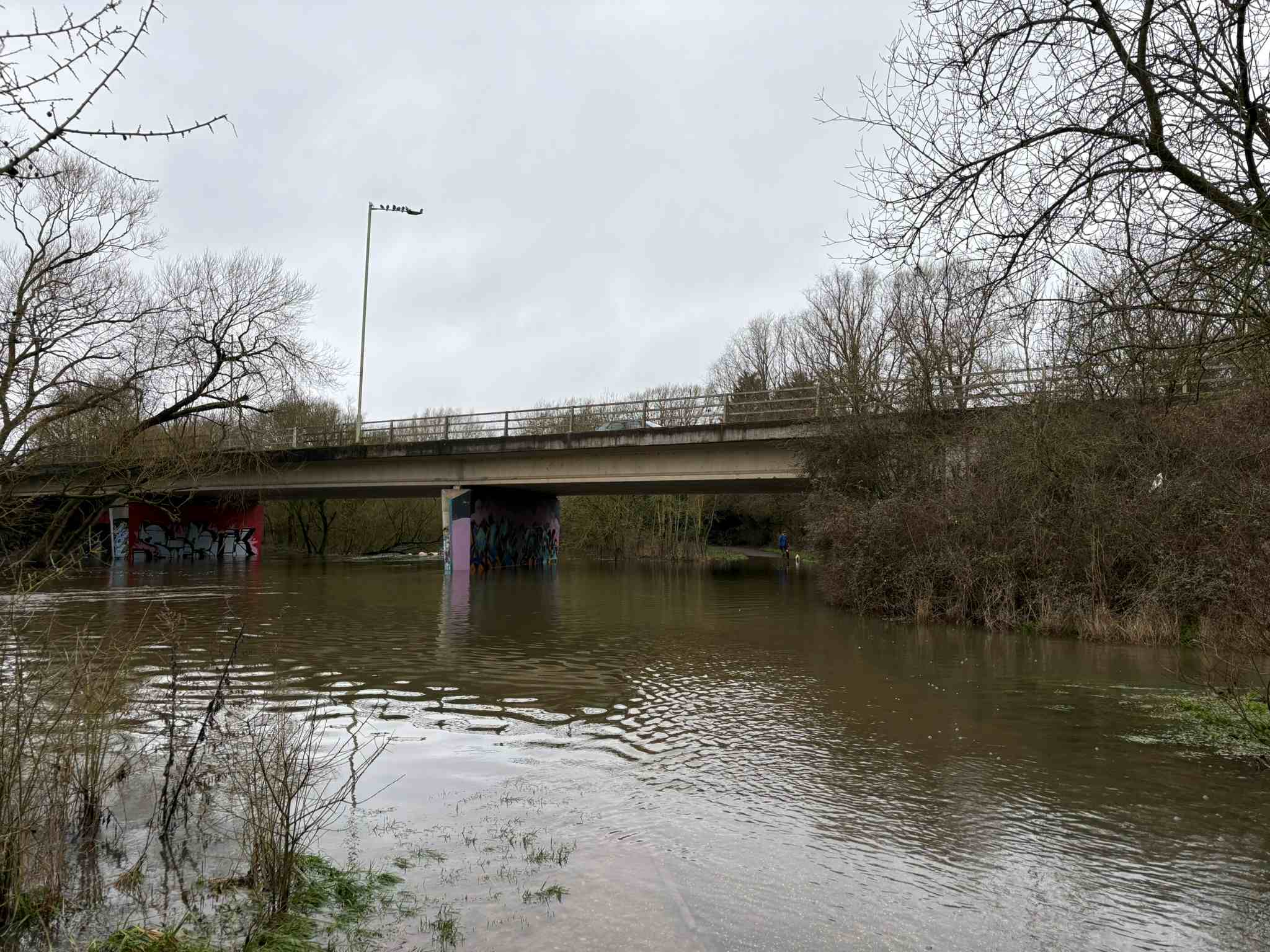
The graph showing the water height at Sindlesham Mill. At 7.47 am, the
water was 0.65m and was steady.The graph showing the water height at Twyford At 7.47 am, the water was 2.69m and was steady.Approaching Colemansmoor Bridge from the A329M bridge, the path is still has a couple of large puddles. Flooding continues under Bader Way.The path beneath the A329M bridge is still flooded.A view across to the Mortimers' Meadow bridge. A view of the path walking towards Mortimers' Meadow bridge.. Boots and long gaiters.
River levels have continued to fall, and in most areas the river is now back within its banks. The paths are open, but remain very muddy in places and can be quite slippery — particularly between the A329M bridge and Colemansmoor Road Bridge.
Under the Bader Way Bridge, the river is still over its banks and flowing across the grass, although the path itself is clear.
Walking on towards the Mortimer’s Meadow Bridge, most of the puddles have receded, leaving mud and silt in places. The meadow remains flooded.
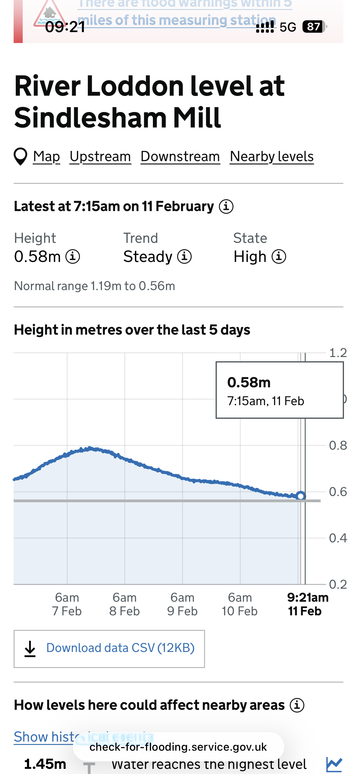
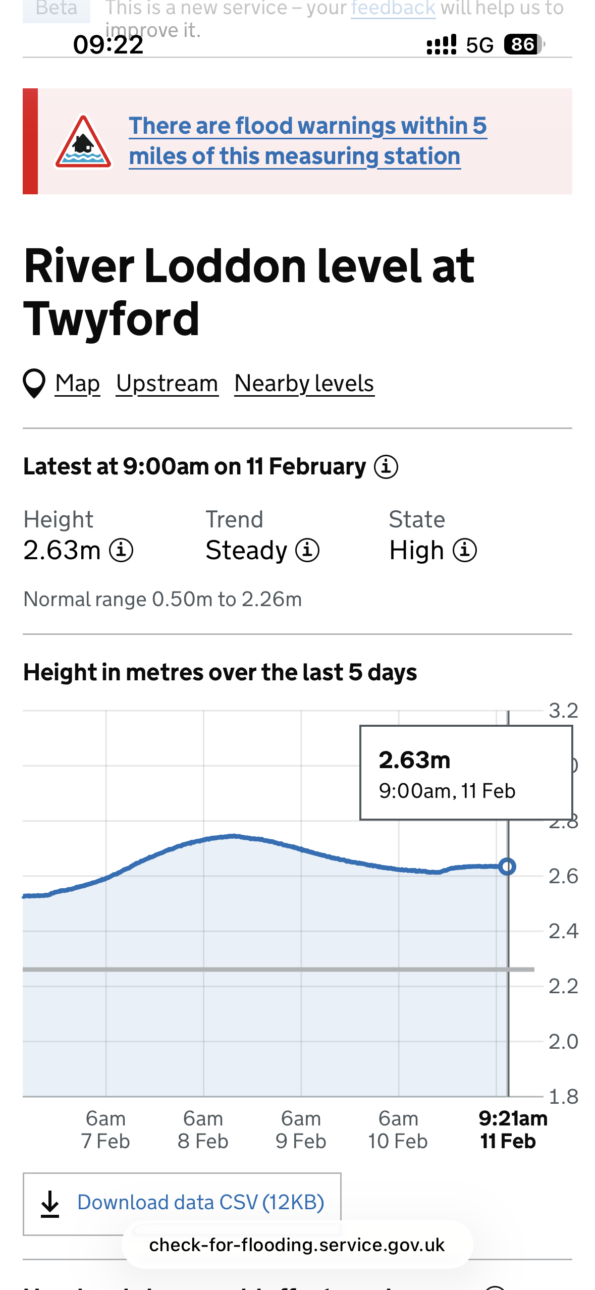
The graph showing the water height at Sindlesham Mill. At 9.21 am, the
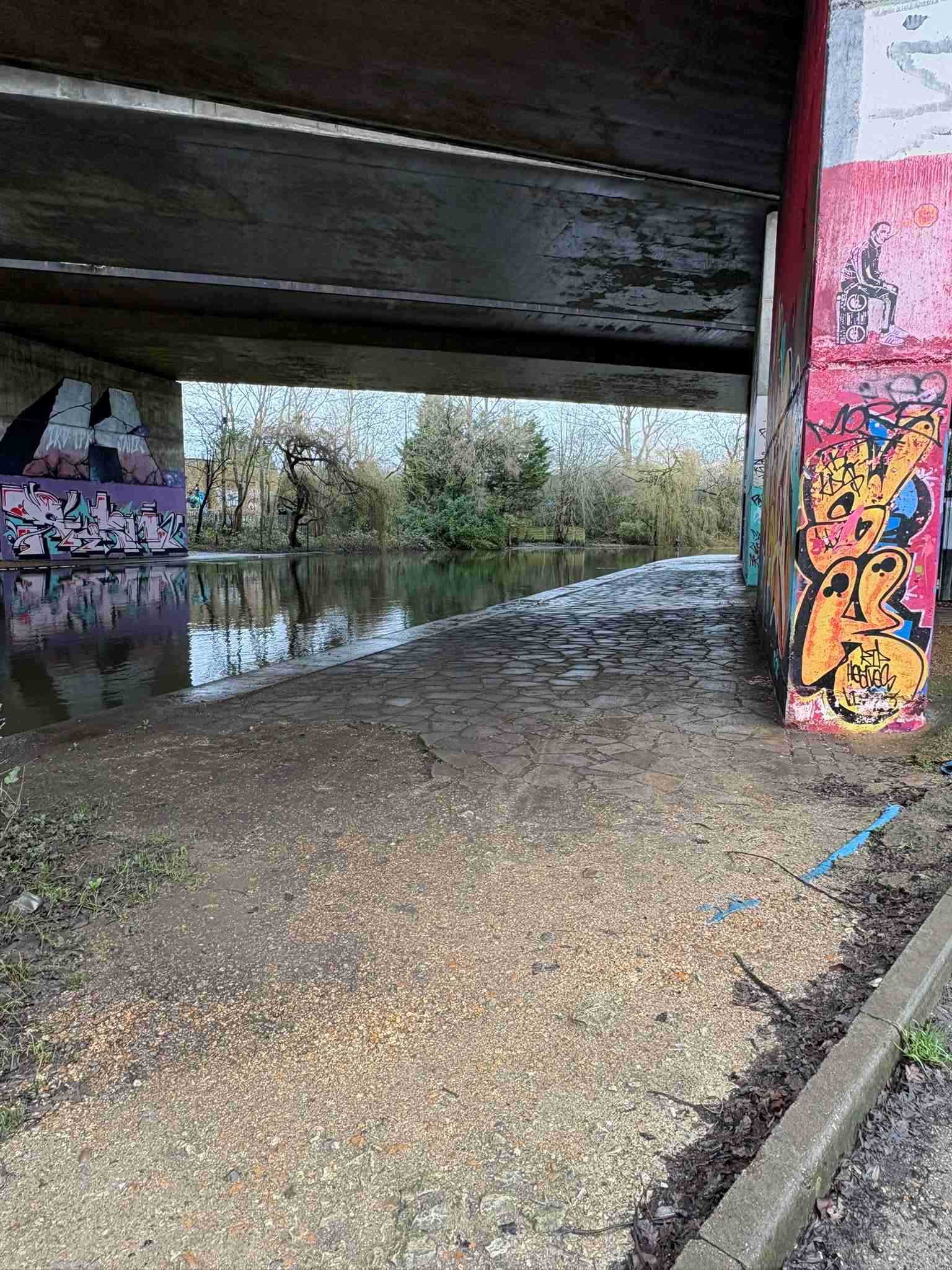
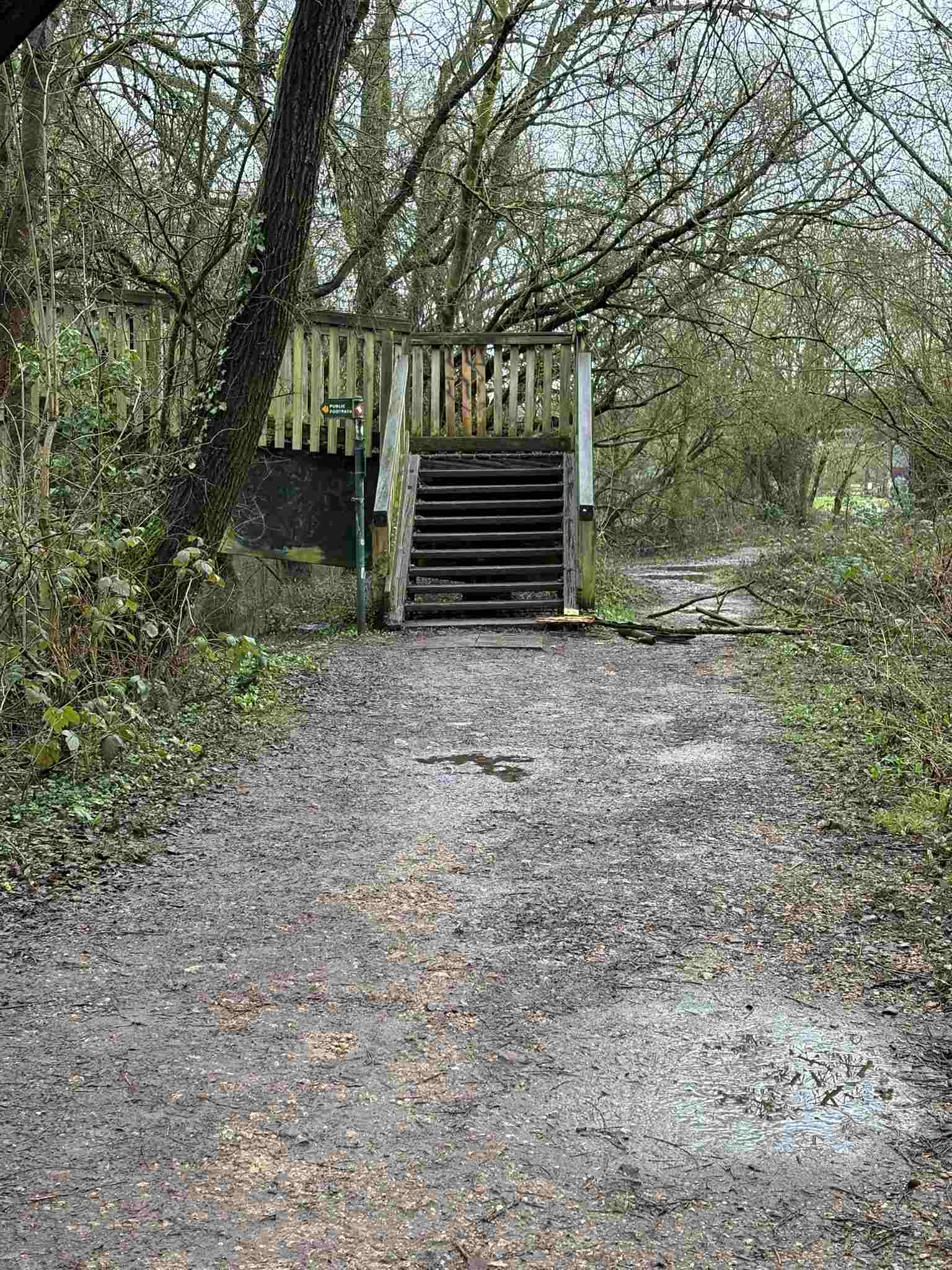
water was 0.58m and was steady.The graph showing the water height at Twyford At 7.47 am, the water was 2.63m and was steady.The path beneath the A329M bridge is clear.Approaching Colemansmoor Bridge from the A329M bridge, the path is still has a couple of large puddles remain. It is sliipery in places This part of the riverbank is still high and overflowing.The path is clear.A view across to the Mortimers' Meadow bridge.


.jpg)
.jpg)

.jpg)
.jpg)
.jpg)
.jpg)